Geography Reference
In-Depth Information
when 'formal' urbanisation (such as extensive
housebuilding) does not occur. There may be
more part-time farming (as farmers take urban
work and urban workers buy a farm as a hobby).
The use of farmland may reflect the closeness of
the city through car boot sales, pick-your-own
crops and horse livery. The appearance of the
countryside may become important, and there will
be pressures from urban people to buy houses (and
to have more houses built) in the surrounding
towns and villages. This can give rise to the 'urban
village'. Newcomers restore old properties in
pseudo-traditional styles and take over village
institutions. They may use the village shop less but
support the village school against closure. They
may be uninterested in the fate of the bus service
but keen to oppose the development of
employment in the village and new housebuilding.
Longer-term residents of the village may be more
favourably disposed to these. The two groups
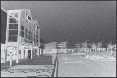
Plate 21.1
New retail site on the edge of Lancaster
and Morecambe—a typical car-based land use on the
urban fringe.
and rural values and expectations for the accessible
countryside come into the sharpest conflict and
proximity.
The changes in economic activity and social
structure on the fringe are usually pervasive, even
Box 21.3
Lancaster
Lancaster is a small city in northwest England with a
population of about 50,000, and it is typical of many
similarly sized towns. It is growing slowly but without the
economic dynamism of a capital city or a boom town. Its
direction of expansion is limited by physical and
development cost barriers such as a river and a
motorway (see Figure 21.2). The expansion of the city
has been guided by three principles:
•
Expansion should be adjacent to the existing built-up
area, so avoiding leapfrogging and ribbon
development, and minimising the cost of infrastructure
(see Plate 21.2).
•
The urban fringe is an acceptable location (even the
ideal one) for activities that are either too land-extensive
to fit into a mediaeval urban core (e.g. a university,
supermarket and sports centre), or generate a lot of
traffic (a hotel and leisure park), or are un-neighbourly
land uses for a built-up area (e.g. kennels, a prison and
slaughterhouse) or are site-oriented (a water treatment
works and microwave towers above the town).
•
Development densities are fairly high so as to keep
the city compact, minimise the loss of farmland and
reduce house prices, since land is expensive. The
hope of development profits is concentrated on the city
edge and inflates land prices there.
Some smaller and picturesque villages around Lancaster
have been 'taken over' by incomers, who work in
Lancaster and who oppose further village expansion.
Other villages with more mixed populations take a more
relaxed view of some types of development.
The map of a small part of eastern Lancaster's fringe
(see Figure 21.2) demonstrates clearly the mixture of
public- and private-sector land uses, which are either
drawn into the fringe from the countryside or are pushed
out to the fringe from the town. Allotments and farms link
to the open fields of the countryside, and the country
house restaurant has similar resonances. Un-neighbourly
land uses (e.g. the abattoir and perhaps the mental
hospitals) and space-extensive ones (e.g. the prison)
compete for space with activities generating a lot of traffic
(e.g. the livestock market and leisure park).
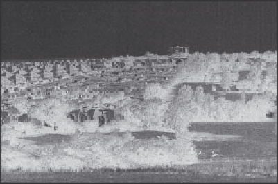
Plate 21.2
Allotments at the edge of Lancaster surrounded
by three generations of private housing and a leisure park
(right) (see also Figure 21.2).