Geography Reference
In-Depth Information
visitors a year, who can experience the 'lost
landscape' of the peat fens.
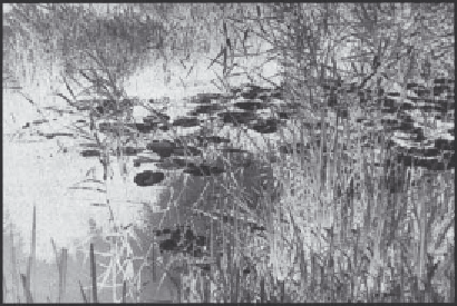
The reserve is about 305 ha and consists of four
sections: Wicken Sedge Fen; Adventurer's Fen, St
Edmund's Fen and, only secured in 1992, Priory
Farm. The most important section—Wicken
Sedge Fen (103 ha) —is bounded by clay banks to
the north and west, on the east by the rising land
of Wicken Ridge and to the south by a broad,
man-made watercourse, Wicken Lode. It stands
like a reverse island, three meters above the
surrounding farmland (Plate 20.2) and is kept wet
by pumping water into it, and through water-
proofing around its perimeter (Friday 1997).
The main problems for Wicken Fen's
conservation have been, on the one hand, falling
water levels and, on the other, encroachment by
scrub. There is a hydrological gradient between
Wicken Sedge Fen and the farmland to the north
and east. This drained, shrunken land due to peat
wastage acts like a sponge for the water in the
reserve through gravity flow (Purseglove 1988;
Friday 1997). 'Fens would quickly turn into
woodland if not continuously wet. Most of
Wicken Fen has thus become a wood in the last
50 years' (Rackham 1986: p. 381). In addition to
falling water levels, a compounding factor was
'lack of management' in that sedge and reed were
not harvested after 1920. However, in 1961 a
management plan was drawn up to arrest the fen's
decline and to restore its former habitats. This new
management has been based, for example, on
reopening old ditches, excavating new ditches,
cutting down trees and reintroducing sedge
harvesting. In 1982, the fen violet reappeared—it
had last been seen in 1916
(ibid.)
.
In 1942, Eric Ennion wrote
Adventurer's Fen
as
a requiem to a disappearing landscape, drained as
part of the 'dig for victory campaign' and
requisitioned for cultivation. Now half a century
later, and looking forward to the next century 'the
last crops of potatoes, linseed and sugarbeet have
been lifted from Priory Farm land and the
combined forces of men, machinery and sheep are
beginning the transformation of arable black
peatland back to fenland' (Friday 1997: xiii).
Therefore, it seems that time is going backwards
in this reserve, and agricultural land is being
reverted, given back to nature, a true example of
wetland restoration.
CONCLUSION
Applied geographical research has a particularly
important contribution to make to the
development of effective programmes for wetland
conservation. Actions are being taken to develop
and implement conservation programmes such as
those undertaken by the Ramsar bureau. However,
a first, crucial, step is an increase in the
understanding and awareness of the value of
wetlands, their rate of loss, and the social and
economic impact of these losses. This includes:
1
Valuing wetlands.
Studies have been undertaken
for some wetlands in Europe and North
America, with a gradual increase in studies in
the tropics. This has increased initial awareness
of the importance of wetland ecosystems, but
it needs to be expanded, coupled with
targeted efforts to increase the capacity of
training institutions to provide instruction in
wetland evaluation.
2
Quantifying the benefits of wetland conservation.
Studies in wetland economics need to go
beyond the analysis of wetland value to
examine the broader economic impact of
wetland conservation and management and,
Plate 20.2
Wicken Fen.