Geography Reference
In-Depth Information
systems. Thus, private developers continue to invest
in drainage and conversion in the expectation that,
even if aquaculture fails, the land is worth more as
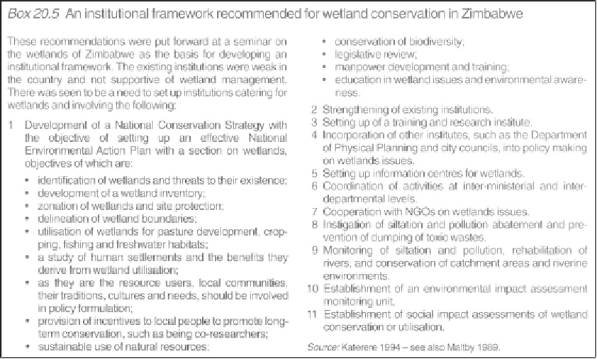
wasteland for housing than as wetland (see also Box
20.5 for an example of 'best practice').
The importance of excessive water abstraction for
commercial agriculture can be seen in the case of
the Tablas de Daimiel wetland, in Spain. Tablas de
Daimiel, a national park in central Spain, is one of
the few floodplain wetlands remaining in the
country (Casado
et al
. 1992) (Plate 20.1). However,
its hydrological and ecological functioning no longer
operates as a natural system. Tablas de Daimiel is
located in the Spanish central plateau, in the semi-
arid region of Castille-La Mancha, in the province
of Ciudad Real. It was designated a Ramsar site in
1982 and a Special Protection Area (SPA) under the
Birds Directive and a candidate special area of
conservation (cSAC) under the Habitats Directive.
In 1973, it was declared a national park to mitigate
plans to drain this area for irrigation. In the same
year, the first wells were legalised in the area to
irrigate corn and barley, thus substituting traditional,
extensive dryland Mediterranean agriculture of
olives, vines and wheat.
Tablas de Daimiel National Park has a
designated area of 2000 ha, out of a total wetland
area of 8600 ha of a very complex endorrheic
hydro-geological system. It results from a
confluence of surface waters from the Ciguela
River (saline water) and the Guadiana River (fresh
water), small seasonal streams and groundwater
from Aquifer 23, the key hydrological feature in
the Upper Guadiana basin (Cirujano
et al
. 1996;
Llamas 1988). During high groundwater levels, the
wetland is a groundwater discharge area; during
low groundwater levels, it is a groundwater
recharge area.
From the moment that the park was declared,
in 1973, there was an increase from 30,000
irrigated hectares to 130,000 ha in 1989 in the
area surrounding the park. It is estimated that the
aquifer has renewable resources at an average of
335-400 Mm3/yr, yet the net abstraction for
irrigation has been 520-600 Mm3/yr. The
groundwater levels over the last thirty years have
dropped by as much as a metre a year,
compounded by a drought between 1991 and
1995. As a result, from 1984 the park ceased to be