Geography Reference
In-Depth Information
Box 12.2
Groundwater mining and food security in Saudi Arabia
Another case of rapid groundwater development for
Irrigation is found in Saudi Arabia. In the 1980s, as a
result of government policy to increase food self-
sufficiency, large subsidies were made available to
farmers for wheat production. At this time, Saudi Arabia
was dependent upon large imports of wheat annually.
Given the arid nature of the Saudi Arabian climate and
the lack of surface runoff, the growth of wheat was only
feasible through irrigation waters supplied from deep
wells. Speculative development of the groundwater
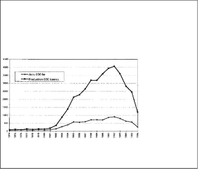
reserves took place through a well-drilling programme
and as a result the area of wheat rose from 60,000-
90,000 hectares in the late 1970s to a peak of over
900,000 hectares in 1992 (Figure 12.6). The actual
production of wheat increased over the same period from
around 90,000-150,000 tonnes to more than 4 million
tonnes. So great was this production that in 1992 Saudi
Arabia was able to export a staggering total of more than
2 million tonnes of wheat.
Figure 12.6
Area and
production of irrigated wheat
in Saudi Arabia.
Eventually, the Saudi Arabian government came to
realise that the subsidies, which were often more than
four times the price of wheat on the world market, made
little economic sense, and in recent years they have been
gradually reduced. As a result, by 1996 the cropped area
for wheat has been reduced to 265,000 hectares, and
wheat production now looks set to fall to around 1.2
million tonnes. However, it has to be stated that this
experiment with irrigated wheat production has resulted
in the severe depletion of the aquifer beneath Saudi
Arabia and a wastage of water that could have been used
for more productive purposes.
on making use of the snowmelt flood wave that
came down the river in April and May. However,
only a small portion of the water was abstracted,
and most of it flowed unused into the Persian
Gulf.
An interesting aspect about the Euphrates is
that at least 88 per cent and possibly over 95 per
cent of the flow of the river is generated by
precipitation falling over Turkey. The remaining
flow comes from within Syria. No flow at all is
provided by Iraq. As a result, there is a growing
conflict between the upstream and downstream
states as to the uses of the water. Turkey's position
is that as almost all of the water of the Euphrates is
generated within its boundaries it has a strong
claim to make use of as much of the waters of the
river as it wishes. On the other hand, Iraq's
position is that since it has been using the waters
of the river for over 5000 years it has a right to go
on using them without hindrance.
With the construction and opening of the
Ataturk Dam in the early 1990s Turkey has
become a major user of Euphrates water for
irrigation purposes. Turkey stated that it would
guarantee a downstream flow of at least 500 m
3
per second. However, this represented only about
half the natural flow of the river on an annual basis,
and so both the downstream states of Syria and
Iraq reacted strongly against this declaration.
Turkey was not willing to change its position and
went ahead with its irrigation schemes on the
Harran Plain and adjacent areas (Figure 12.7). One