Geography Reference
In-Depth Information
Box 6.2
Methods for regional hazard assessment
Two parameter methods for regional hazard assessment
are illustrated in summary form. Both methods require
the selection of factors that are important in determining
the level of hazard in the areas being studied. A number
of factors are common to both methods, although
expressed in different ways. These include the history of
landsliding, the availability of susceptible material, and
slope angle. Both methods are relatively easy to apply
with limited expertise, and they both provide a simple but
clear classification of landslide hazard in a form suitable
for use by planners and land managers.
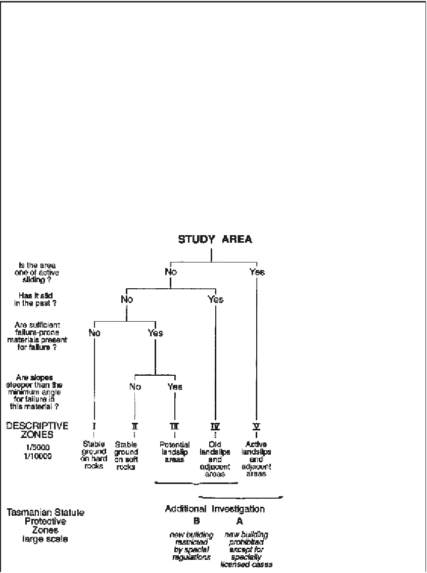
The Tasmania method (Stevenson 1977; Figure 6.3)
is hierarchical, with each of the parameters having a
different level of importance. It takes the form of a
decision tree, with each decision providing a subdivision
of a higher-order class. It could, therefore, be used to
map an area in anywhere from two to five hazard classes,
depending on the resources available and level of detail
required. Local knowledge and knowledge of previous
landsliding has determined the type of parameters
chosen and their relative importance.
The Montrose method (Moon
et al
. 1992; Table 6.2)
is designed specifically to assess debris flow hazard
in an area where there is a real threat but little recent
history of debris flow. Consequently, the selection of
parameters is more theoretically based. For example,
areas with little outcrop are considered likely to provide
a potential supply of debris, while landslides may
actively feed into gullies where debris flows can be
generated. Steep, high slopes, together with large-
volume landslides, ensure a high volume and rapid
supply of material to debris flow initiation sites. The
hazard assessment classes are decided partly by
judgement and partly objectively. Where all hazard
factors are present in a catchment, the area is
classified as 'high' or 'very high' hazard. The class
'very high' has particularly large volumes of modern
landslides. To qualify as 'medium', parameters 1 and 2
must present some degree of hazard, along with
hazard recorded for at least one of the other
parameters. Other catchments not meeting these
criteria are classified as 'low' hazard.
Figure 6.3
Tasmania hazard
zonation scheme.
Source:
Stevenson 1977.