Geography Reference
In-Depth Information
equated with 'probability' and 'magnitude',
respectively, and are taken together to represent
hazard for a given place. Thus hazard is defined as
the probability of occurrence (frequency) of a
given magnitude of event and is incorporated in
the hazard/risk equation as:
where, in the case of landslides (Varnes 1984;
Crozier 1993):
hazard
is the probability of
occurrence (frequency) of a given
magnitude
of
failure;
magnitude
refers to the impact
characteristics of the process;
elements at risk
are
people, property, livelihood and other values;
vulnerability
is the expected degree of loss for a
hazard×elements at risk×vulnerability=total risk
Box 6.1
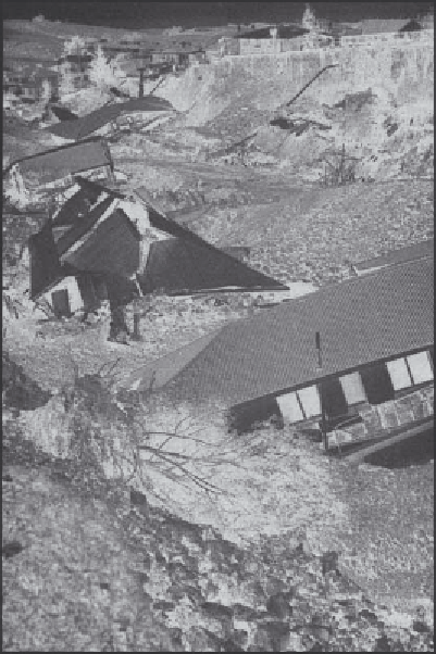
The East Abbotsford landslide disaster
IMPACT
At 9.05 pm on the dark and wet winter night of 8 August
1979, a large slice of suburban land in Abbotsford, South
Island, New Zealand, suddenly slid downslope, trapping
seventeen people, destroying sixty-nine individual homes
and dis-placing 200 people (NZ government 1980).
Because early warning signs of instability had been
heeded and an efficient emergency management
capability was available, nobody was killed, but the costs
were high. The total cost from the destruction of houses,
urban infrastructure and relief amounted to about NZ$15
million in today's terms (Plate 6.2).
A sophisticated national insurance scheme designed
to cope with such disasters, together with government
and voluntary relief measures, meant that many of the
residents were compensated for much of the direct loss.
However, less obvious costs, such as depressed property
values in the surrounding area, psychological trauma and
the expense of a prolonged commission of inquiry, were
not immediately appreciated.
TYPE OF LANDSLIDE
Block slide of sandstone involving bedding plane failure
along a weak layer of montmorillonite clay, dipping at 7°.
Displacement of 50 m occurred in 30 minutes, leaving a
graben of 30 m depth at the head of the slope.
CAUSES
Preconditions
•
Unstable geological structure with bedding planes
dipping into the valley at angles close to the
inclination of the hill slope.
•
Permeable material overlying less permeable
material, allowing perched water table to develop
above the shear plane.
•
A very weak montmorillonite-rich layer along the
shear plane.
Preparatory factors
•
Deforestation within the previous 150 years: lowering
evapotranspiration, removing mechanical root
reinforcement.
•
Urbanisation within the previous forty years: cutting,
filling, modification of surface drainage.
•
Quarrying of material from the toe of the slope ten
years previously, thus removing lateral buttressing
support.
Triggering factors
Unknown; possibly a combination of leakage from a city
water supply pipeline and rainfall.
Plate 6.2
Destruction in the suburb of Abbotsford, caused
by the block slide of 8 August 1979 (
photograph: Bill
Brockie
).