Geography Reference
In-Depth Information
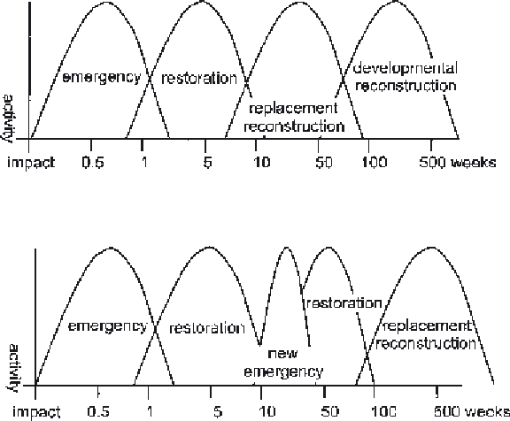
Figure 5.5
Comparison
between Kates' and Pijawka's
(1977) model of the stages of
recovery after disaster (A)
and Hogg's (1980)
application of this schema in
the Friuli region, Italy (B),
where in 1976 two damaging
earthquakes occurred with a
six-month time interval
between them.
have been conducted by geographers, but their
work has been somewhat overshadowed by that
of geophysicists and sociologists. Yet the human
ecological tradition of hazards studies, which
stretches back more than fifty years, stems directly
from the work of geographers (White 1973).
One suspects that in the field of natural
hazards in general, and studies of volcanic and
seismic hazards in particular, a great geographical
challenge has not been met. There is considerable
scope for the formulation of general spatial
models that integrate the physical hazard, in
terms of the distribution of risks and impacts,
with the human response in terms of the patterns
of vulnerability, impact and emergency response.
Dynamic spatial patterns are thus created by
distance decay and the temporal evolution of
disaster scenarios. Yet almost no geographers are
actively engaged in spatial analysis of data on
disaster impacts, at least not with a view to the
creation of general models. This is a pity, as spatial
regularities are undoubtedly waiting to be
discovered, and robust spatial models would
greatly aid in forecasting the pattern of impacts,
damage and casualties to be expected when the
earth shakes or volcanoes erupt.
of the International Decade for Natural Disaster
Reduction (IDNDR 1990-2000) and have given
rise to a growing methodological debate. One
aspect of this is that substantial new prospects have
been opened up by the Internet, which has
facilitated both distance learning and the
acquisition and use of data.
CONCLUSION
So compelling are the phenomena involved that
natural hazards studies are almost by definition
applied forms of research. Indeed, the field is
dominated by practical problems, such as how to
provide a safer environment and apportion scarce
resources for mitigation and emergency
management. In disasters, time is the backbone
of events and geographical space is their medium
of expression (Alexander 1995). However, even
though spatial relationships are fundamental to
the interpretation of many processes in natural
catastrophe, the role of geographers has been
muted. Excellent studies of urban and social
change during reconstruction, and of the
geomorphology of tectonic and volcanic hazards,