Geology Reference
In-Depth Information
lateral extrusion) of the South Tibet
block. Relative movement continues
into the Asian plate north of the BNS
suture, but at a slower rate (Figure 11.4).
Orogenic strain
Rough estimates of bulk two-dimen-
sional shortening strain across the
central part of the orogen, using the
displacement data recorded above,
are ~78% for the Himalayas (i.e. the
Indian upper-middle crust) and ~60%
for the South Tibet block (the Asian
crust). The shortening across the
Himalayas is accomplished mainly by
crustal thickening, much of which has
been removed by erosion. The present
Moho depth descends from ~40 km at
the orogenic front to ~70 km beneath
the ITS suture and remains around
that level across the South Tibet block
(see Figure 11.3D). The thickening
of the Asian crust is thought to have
taken place mainly during the pre-
collisional subduction phase; during
the collision phase, the warm middle
and lower crust would have deformed
partly by lateral ductile flow towards
the east, corresponding to the sideways
block faulting of the upper crust.
The Western Alps belt
The French-Swiss sector of the Euro-
pean Alps is the best known of all the
young orogenic belts and has been
studied intensively by some of the
most famous geologists in the world
since the mid-nineteenth century.
Unfortunately, however, it is extremely
complex - more so than the Himala-
yas - and therefore cannot, in some
respects, be regarded as typical of oro-
genic belts in general. Several reasons
for this are apparent from Figure 11.5,
which shows in a simplified way the
general shape of the western end of
the Alpine-Himalayan orogenic belt
system, from Gibraltar in the west to
the Carpathians in the north-east and
Greece in the south-east. We can see
from this map that the orogenic belt
occupies both sides of the western
Mediterranean in southern Spain and
North Africa, then swings up through
Sicily and the Apennines. In south-
eastern France, it curves around
11
90
91
o
40
Tarim basin
Qaidam basin
Tibetan plateau
o
30
Himalayas
Indian plate
o
o
o
80
100
90
Figure 11.4
Velocity vectors (red arrows) relative
to stable Eurasian plate derived from repeat GPS
measurements. Note that the velocities decrease
northwards and indicate flow is progressively
north-eastwards then eastwards and south-
eastwards in the eastern part of the sector.
Based on Gan et al. (2007).
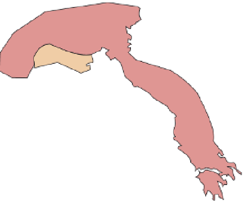
Figure 11.5
Alpine orogenic belts of the
western and central Mediterranean.
These orogenic belts, shown in red,
separate continental crust of the
European plate from that of the African
plate. The belts are divided into external
zones overthrust onto European or
African plates respectively and internal
zones, representing the uplifted
central crystalline complexes. Note
the promontory of African plate crust
in the Adriatic, extending into northern
Italy. The Balearic and Tyrrhenian seas
represent new ocean crust created by
the anticlockwise rotation of the Italian
peninsula. In the south-eastern portion
of the map, Neotethys ocean crust is
subducting beneath Sicily. Based on
Fig. 1 in Coward & Dietrich (1989).
Carpathians
overthrust
direction
internal/external
zone boundary
boundary between Northern
and Southern Alps
Eastern Alps
external
zones
Western
Alps
internal
zones
younger
cover
Fig.
11.7
Southern Alps
Apulia
Dinarides
int.
zones
EUROPE
Balearic
Sea
external
zones
Corsica
Adriatic
Sea
spreading
Betic Alps
Sardinia
Tyrhennian Sea
Majorca
internal
zones
Mediterranean Sea
external
zones
internal
zones
internal zones
Sicily
subduction
zone
300km
Atlas mountains
AFRICA


Search WWH ::

Custom Search