Geology Reference
In-Depth Information
Examples of modern orogenic belts
11
11
11
Examples of modern orogenic belts
86
87
The present-day system of orogenic
belts is briefly described in Chapter
2 (see Figure 2.2). We shall take, as
examples of modern orogenic belts,
two sectors of the Alpine-Himalayan
orogenic belt that are comparatively
well known: the central Himalayas and
the Western (French-Swiss) Alps to
represent the continent-continent col-
lision type of belt, and the Canadian
sector of the North American Cordil-
leran system as an example of the con-
tinental margin type. The Cordilleran
system runs along the western side of
the Americas from Alaska to southern
Chile. Active subduction in the North
American Cordillera is confined to two
comparatively short sectors: north
of the Aleutian trench in Alaska, and
west of the Cascades volcanic arc in
the north-western USA (see Figure
3.6B). The remainder of this system,
including the Canadian sector, lies
adjacent to major transform faults and
contains multiple displaced terranes.
The layout of the modern oro-
genic belt network is a result of plate
movements during the period from
the Jurassic to the present day and
is summarised in Figure 11.1.
of all, the Himalayas. The Himalayan
sector itself is over 2,500 km long and is
draped around the northern perimeter
of the Indian continent, which projects
into it at its western and eastern ends
(Figure 11.2). It contains several of the
world's highest mountains, including
Mount Everest, and is bordered to the
north by the high Tibetan plateau, with
a mean elevation of over 5,000 m. The
western (Pakistan) sector is known as
the Karakorum.
The Himalayan belt is the result
of the collision of the Indian conti-
nent with Central Asia (Figures 11.1,
2), which is itself an amalgamation of
several continental blocks including
North and South Tibet and Tarim to
the north, and the South-China and
North-China blocks to the north-east,
all of which joined the Siberian core of
Asia during the Mesozoic. The sutures
between these blocks represent lines
of weakness within the Asian conti-
nent, which were exploited during the
Indian-Asian collision, and along which
renewed activity in the form of thrust-
ing or strike-slip faulting took place.
Our knowledge of the history of the
Himalayan belt is assisted by detailed
information from the Indian Ocean
magnetic-stripe data (
see
Chapter 3;
e.g. Figure 3.5 and 3.6), from which it
is deduced that India, having detached
from the Gondwana supercontinent
during the Cretaceous, probably
reached the margin of the Asian con-
tinent at around 50 Ma ago. Prior to
The Himalayan belt
The Himalayan orogenic belt is part
of the long and complex system of
orogenic belts that extends from the
western end of the Mediterranean to
Burma (Myanmar) in the east (
see
Figure
2.2) and includes the great chains of
the Alps, Carpathians, Caucasus and
Zagros ranges, and, most prominent
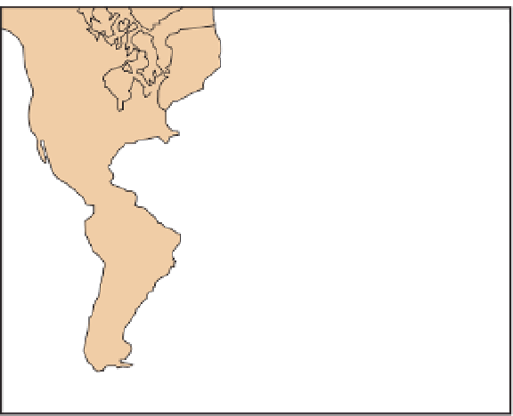
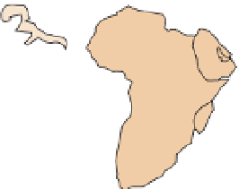
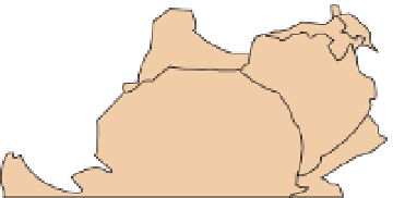
Figure 11.1
The break-up
of Pangaea. During the
Jurassic, Pangaea started
to break up by the opening
of the central Atlantic,
followed in the Cretaceous
by the opening of the South
Atlantic and consequential
convergence of Africa and
Europe. The north Atlantic
would not open until the
Palaeocene. Also in the
Cretaceous, India broke
away from Gondwana and
moved north towards Asia,
ultimately to create the
Himalayas. Based on Smith
& Briden (1977) map 7.
O
60
Eurasia
North
America
O
30
O
0
South
America
Africa
O
30
India
Australia
Antarctica
O
60


Search WWH ::

Custom Search