Geology Reference
In-Depth Information
0
0
0
0
30
60
A
3
continental
shelf
10-75Ma
NORTH
AMERICA
10-75Ma
tf
EUROPE
10-75Ma
12
13
75-135Ma
>135Ma
75-135Ma
ridge
axis
tf
AFRICA
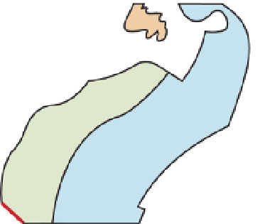
Figure 3.6
Dating the ocean floor.
A.
The age distribution of the ocean floor, dated
by magnetic stratigraphy, shows evidence for the opening of the Atlantic Ocean
from the concordant pattern of dates, which get younger towards the axis of the
mid-Atlantic ridge.
B.
In the NE Pacific Ocean, the age pattern is discordant with
the subduction zones and transform faults that make up the northern and eastern
boundary of the Pacific plate. The large arrows give the direction of movement
of the Pacific plate relative to the American plate. The eastern boundary of the
Pacific plate is marked by a ridge (heavy black dashed lines) which separates
it from the Farallon plate in the north and the Cocos plate in the south, both of
which have been mostly subducted beneath the Americas plate. Transform faults
(tf), dashed red lines; subduction zones (sz), thick black lines. Note that part of
western California and the Baja California peninsula (WC) is actually part of the
Pacific plate. Based on Larson & Pitman (1972).
0
150
0
120
B
0
60
tf
Bering
Sea
AMERICAN PLATE
Cascades
volcanic arc
sz
x
x
10-35Ma
Farallon
plate
35-75Ma
x
x
sz
>75Ma
x
San Andreas
transform fault
tf
0
30
The plate tectonic model
The final stage in the construction of
the plate tectonic model was based on
the proposition that both continental
and oceanic crust must behave in a
semi-rigid manner, moving laterally
as single units or blocks, and that rela-
tive movement between the blocks was
concentrated at their boundaries. This
proposition arose from the observa-
tion that linear features on the ocean
floor, such as faults and the striped
magnetic pattern, were essentially unaf-
fected by warping or bending such as
might be expected if the ocean floor
were to behave in a 'plastic' manner.
The opposing coastlines of Africa and
South-Central America still show a
good fit (
see
Figure 3.1) despite having
travelled away from each other for
tf
Cocos
plate
PACIFIC PLATE
10-35Ma
35-75Ma
35-75Ma
>75Ma
sz
0-10Ma
tf
This palaeomagnetic evidence proved
that the continents making up Gond-
wana and Laurasia had indeed moved
apart, and that the space between
had been filled by new ocean crust.
However, ocean crust could not
be continuously created without it
being destroyed elsewhere, and the
obvious sites for destruction were the
deep-ocean trenches, as suggested
in the conveyor belt model. The new
palaeomagnetic dating evidence dem-
onstrated that ocean crust adjacent to
the trenches shows a variety of ages;
that is, the age pattern is 'discordant'.
Figure 3.6B shows the age pattern of
the north-east Pacific Ocean floor. The
age stripes are aligned north-south
and become younger towards the
American plate, because the oceanic
crust of the Pacific plate has been
destroyed along the subduction zones
on its northern and eastern side.
The above evidence confirmed
that the conveyor belt model for the
ocean floor was essentially correct.


Search WWH ::

Custom Search