Geology Reference
In-Depth Information
have been ascribed to more vigor-
ous oceanic convection and shallower
subduction. It seems highly probable
that the heat flow through the Earth's
surface was considerably higher during
the Archaean than at present, which
helps to explain these observations.
In describing examples of orogen-
esis in the Archaean, therefore, we look
at two regions where the geology is
comparatively well known, with com-
prehensive dating coverage, but whose
limits cannot be established because of
the fragmentation referred to above, so
that the former extent of these Archaean
orogenic belts is uncertain. Archaean
regions are commonly divided into two
basic types -
granite-greenstone
and
high-grade gneiss
, but these distinc-
tions are based mainly on the grade of
metamorphism and degree of deforma-
tion at the current level of exposure, and
do not reveal any fundamental distinc-
tion. The
Superior Province
of Canada
contains typical examples of granite-
greenstone terrain, and the North
Atlantic craton of southern Greenland
(
see
Figure 12.9) is often cited as an
example of a high-grade gneiss terrain.
each characterised by a distinctive
rock suite or metamorphic grade. They
range in width from 40 km to 200 km
and are generally separated by a fault or
boundary zone across which the meta-
morphic grade changes abruptly. The
province as a whole is dominated by
granitic rocks. In some cases, rock units
can be correlated across the domain
boundaries so that the domains do
not all represent separate terranes.
There are three major types of
domain: 1) the
high-grade gneiss
type
consisting of
orthogneisses
and grani-
toid rocks with only minor
supracrustal
components; 2) the
granite-greenstone
type; and 3) the
metasedimentary
gneiss
type. Some granitic domains,
such as Berens River and Winni-
peg River, contain components over
3000 Ma in age and may represent
micro-continents about which the
younger supracrustal domains were
amalgamated. Metamorphism in the
granite-greenstone domains ranges
from greenschist to amphibolite facies,
and in the metasedimentary domains
is typically amphibolite facies. The
domains are believed to have been
tectonically amalgamated into a coher-
ent craton at about 2700 Ma ago.
The narrow
Pikwitonei domain
at the north-western margin of the
Superior Province (Figure 12.11) is a
typical high-grade gneiss belt with
granulite-facies metamorphic assem-
blages in a variety of lithologies,
including 3400-3000 Ma orthogneisses
and more massive younger tonalitic
plutons. Several phases of high-grade
metamorphism occurred in the period
2716-2642 Ma, the youngest being
associated with development of the
major NE-SW-trending deformation.
The
Sashigo
and
Berens River
domains, which together form a block
over 300 km wide, contain isolated,
thin
greenstone belts
surrounded by
extensive granite and gneiss units,
the Berens domain being almost
entirely dominated by granitic rocks.
Granitic basement over 3000 Ma in
age has been identified beneath the
greenstone cover. The Pikwitonei
12
110
111
Hudson
Bay
post-
Archaean
cover
Pikwitonei
55N
Sashigo
The Superior Province of Canada
This large Archaean outcrop (
see
Figure
12.9) forms the core of the Precambrian
shield of North America around which
are draped the Proterozoic belts of the
Trans-Hudson and Grenville orogens.
It consists of a number of oceanic and
continental terranes, formed over a
period of ~3700 Ma to ~2650 Ma, that
have accreted along a convergent plate
margin about 1000 kilometres long in
a series of separate collision events.
There are eleven major zones, known
locally as sub-provinces or '
domains
',
Berens
post-
Archaean
cover
Red
River
Uchi
ER
English River
50N
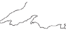
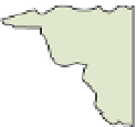
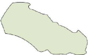
Figure 12.11
The Superior Province. Simplified
map of the western Superior Province showing
the subdivision into zones (known in Canada
as domains) based on their predominant
rock type. Four main types are recognised: 1)
high-grade gneiss domains (blue); 2) granite-
greenstone domains (green); 3) granite domains
(pale red) and 4) metasedimentary domains
(yellow). Several (but not all) domains represent
separate terranes. The Wawa is a 'super-
terrane' (see text). WR, Winnipeg River. Based
on Card & Cieselski (1986).
WR
WR
Wabigoon
Quetico
Q
Quetico
Wawa
Wawa
Lake
Superior
Wawa
post-
Archaean
cover
Minnesota
River
250km
90W


Search WWH ::

Custom Search