Geography Reference
In-Depth Information
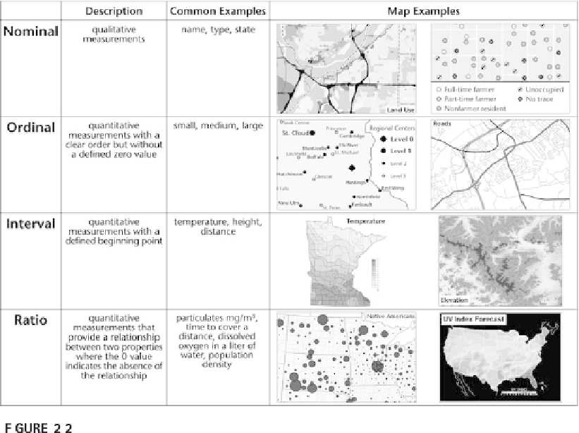
Measurement types with map examples.
ical to the success of GIS. John Sinton was an important and active contribu-
tor to this group.
Sinton devised a scheme for considering space, time, and properties in
three possible roles: fixed, measured, and controlled. When space is fixed, a
measuring device (e.g., tide gauge, stream gauge, NO
2
, etc.) measures an
attribute at a set interval of time (e.g., constantly, every 10 minutes, once a
day, etc.). Measuring devices often use time intervals as the control. They
produce information about a single place. People usually collect geographic
information about multiple places by fixing the time and measuring charac-
teristics of space or some other attribute, and controlling the space or attrib-
ute.
The distinction between what is controlled and what is measured is
important for geographic representation. If the attribute is fixed and the
space is measured, the resulting representation is a
vector representation
showing the extent of the attribute; if the space is fixed and the attribute is
measured, the resulting representation is a
raster representation
. Of course,
there are exceptions and limitations to this approach, which is why we say
it is the way that geographic information is
usually
collected. First, point
data—for example, the location of the stream gauge or a measurement of
soil pH, or the location of a truck—does not show extent, but it does show

Search WWH ::

Custom Search