Geography Reference
In-Depth Information
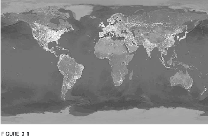
The world-at-night image is abstract. At any one time it is physically impossible to
see the entire world at night. Second, the location of many lighted areas is interpolated.
Source:
http://svs.gsfc.nasa.gov/vis/a000000/a002200/a002276/index.html
representation types in Chapter 9. How well geographic information and
maps communicate greatly depends on how they apply established conven-
tions. The world-at-night image in Figure 2.1 would be much harder to
understand if the outlines of the continents were less clear: it would be diffi-
cult to see which parts of a continental landmass aren't strongly lit if the con-
tinents themselves were not shown in a shade of gray. Understanding the
principles that are implicit in conventions can also help you understand
maps better and prepare you for working with geographic information and
maps.
This chapter familiarizes you with the underlying concepts of geo-
graphic representation and cartographic representation and cartographic
communication. For now, you should keep the two types of representation
separate from each other in the following sense:
geographic representation
deals with how people choose aspects of the world to show on a map or as
geographic information;
cartographic representation
is the process and choices
involved in going from a geographic representation to the symbols to com-
municate with readers. You need to be aware that as we become more versed
in the issues, they often melt into one. Many people refer to them together
as “modeling,” other people will distinguish “models” from “cartography.”
As we learn the specifics of geographic information and cartography, hold-
ing them apart will help you to learn the underlying concepts and skills
required, the role of conventions and the various meanings of models. These
concepts are, of course, fundamental to understanding the conventions used
for geographic information and maps. In the following chapters you can

Search WWH ::

Custom Search