Geography Reference
In-Depth Information
is only of limited validity for an area, such as a theoretical plume extent. A
transformation can produce new GI based on calculations that show a rela-
tion, as in the example of a buffer.
Examples
The two most fundamental GIS operations, buffers and overlays, are exam-
ples of GI representation transformations. Buffers transform position-based
GI into other types of position-based GI or fields. Overlays transform two
position-based GI data sets into one. What these operations involve and how
they transform demonstrates the key role of transformations for GI and its
much greater usefulness compared to maps.
BUFFER TRANSFORMATIONS
A buffer transformation is the simplest transformation to grasp, but its
operation can actually be quite complex. Practically, based on the position
of one or more GI objects, it determines the zone around the objects using
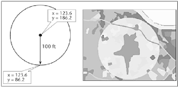
one or more distances. Figure 9.6 (left) shows a simple 100-foot buffer
around a well. But what do the 100 feet (about 30 m) represent? They may
simply be the regulatory zone where no animal waste disposal is allowed.
But it could be based on more complex geographical relationships. Maybe
the 100 feet corresponds to the well recharge zone calculated using a hydro-
logical model that considers both the soil type and geology. The areas of
buffers usually are used to show a geographical relationship. Based on an
understanding of the relationship, distances are used to show the extent of
the relationship. This technique is used to indicate area affected by vehicle
or airplane traffic. Complex models may only use buffers to represent the
results of calculations that work with fields and model things and events in
A 100-foot buffer around a point representing a well produces a vector area or
field (left); Buffered zone of land use around the Cincinnati/Northern Kentucky Airport (right).


Search WWH ::

Custom Search