Geography Reference
In-Depth Information
TABLE 8.2. Comparison of TM and ETM+ Spectral Bandwidths for Landsat 5-TM
and Landsat 7
(Source:
http://landsat.gsfc.nasa.gov/guides/LANDSAT-7_dataset.html
)
Bandwidth (µ) Full Width-Half Maximum
Sensor
Band 1
Band 2
Band 3
Band 4
Band 5
Band 6
Band 7
Band 8
TM
0.45-0.52
0.52-0.60
0.63-0.69
0.76-0.90
1.55-1.75
10.4-12.5
2.08-2.35
N/A
ETM+
0.45-0.52
0.53-0.61
0.63-0.69
0.78-0.90
1.55-1.75
10.4-12.5
2.09-2.35
.52-.90
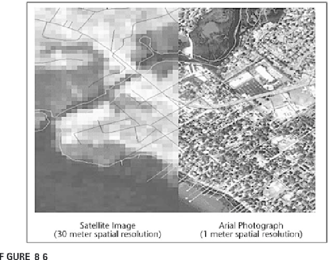
Spatial resolution is usually given in a distance measurement. For exam-
ple, most SPOT sensors have a resolution of 10 m; some have a higher resolu-
tion of 2.5 m. The resolution does not mean that an object of that size can be
consistently
detected and identified. Various atmospheric and situational char-
acteristics play into this. You might think of this as simply the measure of the
side of one of the raster cells detected by the remote sensing technology.
Temporal resolution depends greatly on the spatial resolution of the
sensing technology. High spatial resolutions will record a great amount of
data for a small area, requiring much longer to return to a place than low
spatial resolution sensors. For example, Landsat with 30-m spatial resolution
revisits a place only once every 16 days. The Advanced Very High-Resolution
Radiometer (AVHRR) has a spatial resolution of 1.1 km and revisits a place
once every day.
Spectral resolution is an important characteristic. A coarse spectral reso-
Comparison of spatial resolutions.
From
http://www.csc.noaa.gov/products/sccoasts/html/rsdetail.htm


Search WWH ::

Custom Search