Geology Reference
In-Depth Information
Figure 2.3. Cross-section of a target produced in the Ames Vertical
Gun Range (
Fig. 2.2
). The target consisted of layers of loose sand grains
dyed different colors mixed with epoxy resin. After the
the
target was baked to fuse the grains and epoxy resin, and then sawn
into a cross-section. Shown here is the inverted stratigraphy in the
crater rim (the
“
shot,
”
of ejecta), which is characteristic of
impact craters. The crater is about 0.4m across.
“
overturned
ap
”
Figure 2.4. An aerial view of Meteor Crater in northern Arizona, the
best-preserved impact structure on Earth. This crater 1.2 km in
diameter was formed by a 30m iron meteoroid some 50,000 years
ago (courtesy of Mike Malin).
2.3 Planetary geologic maps
Geologic maps represent a fundamental tool for charac-
terizing the geology and geomorphology of an area and
deciphering its history. The British planetary geologist
John Guest once said
“
a geological map is (to a geolo-
gist) like a graph to a physicist; it allows an understand-
ing of many observations in a comprehensive form that
would be otherwise dif
cult.
”
The basic elements of a
geologic map show the distribution of three-dimensional
rock units (
Fig. 2.6
), the con
guration of the rock units
exposed on the surface of the area mapped, structural
features, such as faults, and the ages of the rocks and
structural features. As is true for all maps, geologic maps
include a scale, orientation (e.g., a north arrow), a legend
explaining the symbols on the map, and the location
of the map area (typically indicated by geographic
coordinates).
The formation is the basic rock unit in mapping.
Formations consist of material of similar rocks, all formed
at the same time, in the same place, and by the same
process. For example, a lava
flow resulting from a single
eruption in Hawaii could be treated as a formation that
would be different from a lava
flow erupted from Mount
Etna in Sicily at the same time, even though both might be
of the same type of rock.
Some formations can be subdivided into members. For
example, during a given eruption sequence, a lava
ow
might be covered by ash from an explosion; the lava
flow and the ash could be called members of the same
formation. Two or more formations that share common
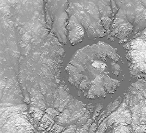
Figure 2.5. A radar image (C-band) taken on NASA
s Shuttle Radar
Topography Mission of the Manicouagan crater, Quebec, Canada;
this impact structure of diameter 100 km formed about 214 million
years ago. Erosion (mostly by glaciation) has removed about 1 km
of rock from its original surface, exposing the deep structure,
including the
'
of the central uplift, which is now surrounded
by Manicouagan reservoir, seen here in dark gray (NASA
PIA03385).
“
root
”
features seen on the Moon. Computer codes were also
being developed for large explosions, which would be
applied later to planetary impact processes.
Through this combination of laboratory experiments,
analysis of remote sensing data, and
field studies, a gen-
eral model of impact processes emerged that could be
applied successfully to the interpretation of planetary
data. The study of impact craters set the stage for the
approach used in investigations of other geomorphic pro-
cesses, such as aeolian activity and volcanism.