Geology Reference
In-Depth Information
(a) dark terrain tectonism
(b) tectonic resurfacing
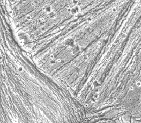
Figure 8.39. Bright grooved terrain in Uruk Sulcus, showing the
older horst and graben structures in the upper right side of the
image being cross-cut by younger fractures and possible tilt-block
faulting in the lower left side of the image (NASA Galileo PIA00280).
(c) volcanic resurfacing
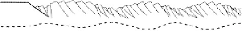
Figure 8.40. An idealized model for the topography and structure of
Ganymede
s grooved terrain. Small ridges and troughs (of
wavelength ~1
'
2 km), potentially formed by tilt-block normal
faulting, are superposed on large swells of wavelength ~8 km. A
deep trough marks the boundary between faulted and undeformed
terrain (left), suggesting deformation of a hanging wall fault block
above a prominent marginal fault (from Pappalardo et al.,
2004
).
-
(d) cross-cutting sulci
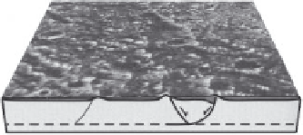
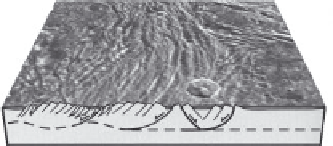
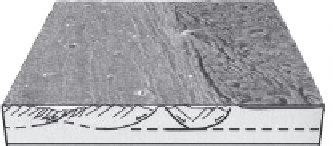
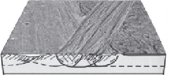
Figure 8.38. A summary model for the formation and evolution of
grooved terrain: (a) normal faults inferred to de
ne furrows in dark
terrain may be reactivated to focus later grooved terrain
deformation; (b) some grooved terrain may form by tectonic
disruption of the preexisting surface without concurrent icy
volcanism; (c) some grooved terrain may form by a combination of
tectonism and icy volcanism that brightens and smooths the surface;
(d) bright terrain swaths can cross-cut one another, dissecting the
preexisting surface into a polygonal patchwork (from Pappalardo
et al.,
2004
).
This feature is about 50 km long, has a typical caldera-like
outline, and appears to be the source for a flow. Except for
these features, obvious
flow lobes and channels are lack-
ing, which could mean that (1) the images are too poor for
recognition, (2) obvious features do not form in
“
cryola-
vas,
(3) features deform beyond recognition quickly, or
(4) such volcanism is rare or absent.
”
8.6.4 Volcanic features
8.6.5 Gradation features
One of the surprises from the Galileo mission was the near
absence of clear evidence for extensive cryovolcanic fea-
tures on Ganymede. Nonetheless, it is currently assumed
that many of the very smooth, lightly cratered plains in
some bright regions were
flooded with melt water or
water-rich materials that erupted onto the surface. In addi-
tion, a few features are suggestive of volcanic vents, the
best candidate of which is in Sippar Sulcus
(Fig. 8.43)
.
The primary processes of gradation on Ganymede are
mass wasting, sublimation, and sputtering. Slopes in the
dark terrain often show V-shaped streaks trending down-
slope, which are interpreted as being zones of mass
wasting. Aprons at the base of some streaks are probably
talus deposits. Detailed analyses of the albedo show that
many Sun-facing slopes are dark, while poleward-facing