Geology Reference
In-Depth Information
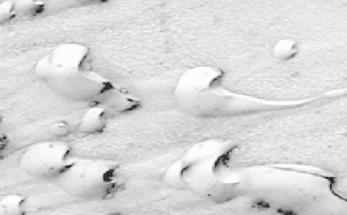
Figure 7.30. Barchan sand dunes in Chasma Boreale; slip faces on the
northeast sides of the dunes (toward the upper right) indicate
prevailing winds in that direction; the area shown is about 1.5 km
wide (NASA MOC 2
-
147).
Figure 7.29. The active dust devil on the horizon over Gusev crater is
one of more than 800 features observed from the rover Spirit during
three complete dust devil seasons. Each season began in late martian
spring when the surface began to heat with the approaching
summer. Also visible in this view is a ripple composed of sand,
showing that both sand and dust are present on Mars (NASA Spirit
image).
the surface
(Fig. 7.29)
. Once the dust has been lifted, it is
easily carried aloft and transported long distances in sus-
pension, even in the thin martian atmosphere.
More than 800 active dust devils were recorded by the
rover Spirit, and dozens more have been imaged from orbit.
The passage of dust devils leaves distinctive dark tracks,
which result from the removal of bright dust to expose a
darker substrate. It is thought that as much as half of all the
dust in the atmosphere has been lifted by dust devils.
Each subsequent mission to Mars has revealed even more
wind-related features like those
first discovered on Mariner
9 images, including dunes, ripples, wind-sculpted hills
(yardangs), and wind-eroded rocks (ventifacts). Most of
the dunes are transverse features (i.e., their axis is normal
to the formative wind direction) and have similar sizes and
shapes
(Fig. 7.30)
to dunes on Earth. High-resolution
images of nearly all regions on Mars show dune
fields and
large patches of ripples, the orientations of which are
controlled by surrounding topography
(Fig. 7.31)
.The
Opportunity rover provided the
first robotic views of
outcrops on another planet. As the rover continued its explo-
ration, it traveled to the rim of an impact crater and imaged
well-formed cross beds exposed in the crater rim, which
Figure 7.31. Sand dunes are seen in many parts of Mars and, just as
on Earth, their location and orientations are often controlled by local
topography; this image was taken in the Iani Chaos region and
covers an area of about 1.0 km by 0.8 km (NASA HiRISE
PSP_008100_170).
have been interpreted as representing fossil sand dunes
(Fig. 7.32)
.
Yardangs on Mars have been imaged in exquisite detail
by the HRSC
(Fig. 7.33)
. These features show that rela-
tively easily eroded materials, such as moderately indu-
rated
fine-grained ash or dust, are common in some
deposits such as the Medusae Fossae Formation.
Evidence of wind erosion is also common at many landing
sites. Ventifacts
(Fig. 7.34)
show the results of blasting by
sand, perhaps derived from nearby sandy ripples
(Fig. 7.29)
. Because very strong winds are needed to
set particles into motion in the low-density martian