Geology Reference
In-Depth Information
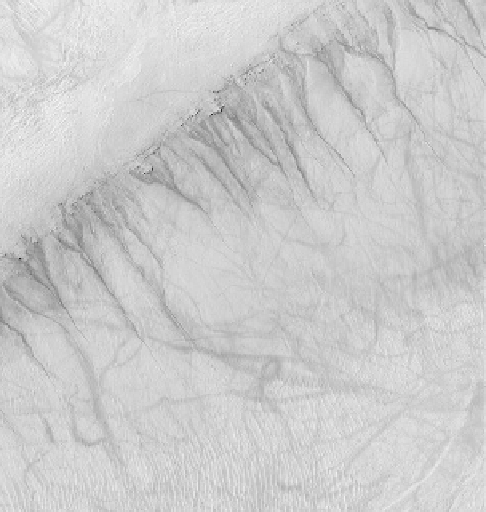
Figure 7.23. These integrated valley networks in the southern
cratered highlands suggest surface run-off from precipitation; the
area shown is about 200 km across (from Mars Digital Image Map,
image processing by Brian Fessler, Lunar and Planetary Institute).
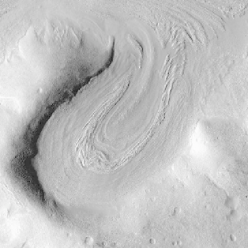
Figure 7.22. An oblique view of an inferred glacier 5 km wide in the
Protonilus Mensae area, showing moraine-like ridges (NASA MRO
CTX frame).
dominated by impact cratering. The
first clues as to the
possibility of water came with the Mariner 9 images
showing channels interpreted to have been cut by
fluvial
activity in the past when the climate was suf
ciently warm
to allow liquid water on the surface. The largest features
are the so-called out
ow channels, some of which are tens
of kilometers across and more than 1,000 km long.
Detailed images of these features reveal complex terraces
and inter-braided channels. Some channels have large
impact craters
“
interleaved
”
with channel elements, sug-
gesting either prolonged
flow or episodic
ow. The sour-
ces for the large
fluvial features include the chaos terrain
and fractures that appear to have released great quantities
of ground water. The presence of giant ripples along some
channels suggests that the water was released as enor-
mous, catastrophic
floods, similar to the channeled scab-
lands in eastern Washington that were formed by the
release of water from the bursting of glacial lakes.
In addition to out
ow channels, other water-carved
features are integrated valley networks
(Fig. 7.23)
.
These are thought by many planetary geologists to repre-
sent run-off from precipitation, although others suggest
that they form by seepage from multiple springs. For
example, gullies on some scarps were discovered in
MOC images and were later found to be actively forming
today. Their morphology and geologic relations to the
Figure 7.24. Gullies seen in Kaiser crater in the southern hemisphere;
the gullies are thought to form from the seepage of water derived
from a distinctive rock layer cropping out on the inner crater wall;
also visible are numerous aeolian ripples (lower part of image) and
squiggly dark streaks left by the passage of active dust devils; the
area shown in this MOC image is 3 km by 3 km (NASA PIA03753).
terrain in which they occur suggest local springs from
distinctive rock layers
(Fig. 7.24)
. One of the most strik-
ing features associated with water is the delta seen in
Eberswalde crater
(Fig. 7.25)
. While surface conditions