Geology Reference
In-Depth Information
kilometers. Most lobate scarps are found in the ancient
heavily cratered terrains and resulted from large thrust
faults.
The Tharsis rise (or
“
bulge
”
) imposes the greatest in
u-
ence on the tectonic patterns on Mars. The rise stands some
10 km above datum and has related tectonic patterns cover-
ing one-fourth of the martian surface. Following its discov-
ery during Mariner 9, two general ideas emerged for the
origin of the Tharsis rise: it could re
ect dynamic uplift and
support by one or more mantle plumes, or it could be an
enormous pile of volcanic materials loaded on an elastic
lithosphere. Gravity data and precise topography from the
MGS have enabled partial testing of these ideas. Coupled
with re
ned geochemical models of the interior, it now
appears that the time-frame needed to develop dynamic
plumes of the size required to support Tharsis probably
exceeds the very age of Mars. Consequently, the loading
model is more widely favored, as reviewed by planetary
scientists Matt Golombek and Roger Phillips (
2010
). It is
also important to note that work by Solomon and Head
(
1982
) suggested that magma fed from plume(s) and erup-
ted onto the surface could provide a type of
“
feedback
”
in
which the fractures providing the conduits to the surface
could be further opened by loading of the erupted materials
onto the surface.
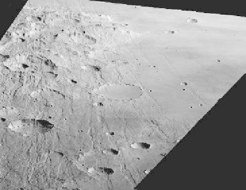
Mapping the Tharsis radial fracture systems
(Fig. 7.18)
and their stratigraphic relations to the lavas and other
materials in the region enables the centers and timing
deformation to be derived. As summarized by Carr
(
2006
), most of the faults associated with Tharsis formed
early in Mars
'
history and the basic structure has not
changed in the last 3 Ga.
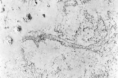
Valles Marineris is a vast rift system stretching eastward
from the Tharsis rise, with which it might be associated
(Fig. 7.19)
. This system can be divided into three parts,
Noctis Labyrinthus in the west, the central rift zone, and the
“
chaos
”
terrain in the east. Noctis Labyrinthus is on the
flank of the Tharsis rise and is marked by intersecting
grabens and elongate pits, suggestive of extension and
subsidence likely associated with the Tharsis uplift. The
main canyon re
ects extensional rifting that has formed a
series of parallel chasmata, some of which are deeper than
7 km, exposing thousands of meters of layered deposits in
the walls. In the middle zone, Ophir, Candor, and Melas
chasmata merge to form a central depression 600 km wide.
Some of the canyons, such as Hebes Chasma, form closed
depressions, suggestive of substantial collapse. Local vol-
canism within the canyonlands along the bases of some
canyon walls was identi
ed by geologist Baerbel Lucchitta
and is of basaltic composition as indicated by high-
resolution multispectral data from the CRISM instrument.
The eastern part of Valles Marineris grades into
“
chaos
”
terrain, characterized by extensive mass wasting that
forms a jumbled relief. The chaos terrain appears to
“
feed
”
an extensive set of huge channels that drain east
and northward into the lowland plains. Although the
chaos terrain includes vestiges of possible extension,
Figure 7.18. An oblique view showing grabens and other fractures
associated with the Tharsis rise in the southern hemisphere where
lavas have
Figure 7.19. A shaded relief map of the Valles Marineris region. This
area, known collectively as the canyonlands, is composed of three
elements: Noctis Labyrinthus in the west, the central canyon system,
and an eastern area characterized by chaotic terrain and out
ow
channels. The area shown is 3,500 km by 6,000 km (courtesy of the US
Geological Survey, Flagstaff).
flooded into the heavily cratered terrain; the higher
density of fractures in the cratered terrain suggests that most
deformation occurred before the latest emplacement of the lavas,
although some lavas are also fractured, indicating continued
tectonism (ESA HRSC #095).