Geology Reference
In-Depth Information
the basis of topographic mapping: highlands, which stand
above 2 km elevation and make up 8% of the planet,
upland rolling plains, which are between 0 and 2 km
elevation and constitute about 65% of Venus, and lowland
areas, which are below the 0 km datum and represent
about 27% of the surface. Both the highlands and parts
of the rolling plains are generally radar-bright, while the
lowland plains are typically radar-dark, suggesting low-
backscatter surface materials such as smooth lava
ows
and
fine-grained sediments.
The mountains Maxwell Montes at 65.2° N, 3.3° E are
nearly 800 km across and rise in elevation to 11.5 km, mak-
ing this the highest feature on Venus. It is part of Ishtar Terra,
a plateau that is a few kilometers above datum. The other
large upland region is Aphrodite Terra, which stretches
along the equator eastward from Ovda Regio more than
10,000 km to the east. This region rises gradually from the
lowland plains and in places nearly reaches 6 km high.
Chasmata, or rift valleys, are found along the equator
and in the southern hemisphere and represent crustal
extension. The lowest area on Venus is Diana Chasma, a
trench 2 km deep centered at 14° S, 156° E. Venus, there-
fore, has a maximum relief of about 13 km, which can be
compared with the relief on Earth of 20 km (measured
from the peak of Mount Everest to the bottom of the
Mariana Trench on the
floor of the Paci
c Ocean).
Because surface temperature and atmospheric pressure
vary with elevation, the venusian summit regions average
374 °C at 41 bars, while the lowlands are at 465 °C and 96
bars. This range in conditions could lead to differences in
surface chemistry, as noted for the high radar emissivities
seen at higher elevations, as well as in geomorphic pro-
cesses. For example, winds at the higher elevation might
need to be stronger to entrain particles than at lower
elevations because of the lower atmospheric densities.
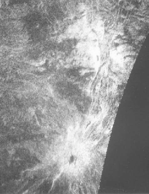
Figure 6.8. An Earth-based radar image showing Beta Regio
provided the
first hints of tectonic and volcanic features, suggested
by the linear radar-bright fractures connecting zones with radial
patterns thought to be volcanoes (Arecibo Observatory image
courtesy of Don Campbell of Cornell University).
radar-bright terrains were identi
ed and named, such as the
“
Alpha
”
and
“
Beta
”
regions. Except for these and a few
other features, names on Venus are of feminine derivation.
Key to understanding the general geomorphology and
surface processes of any planet are topographic data, as
provided by the Pioneer Venus and Magellan spacecraft.
Because Venus lacks an ocean today, the topographic
reference datum is the mean planetary radius.
Figure 6.4
graphs the distributions of elevations for Venus compared
to Earth. The bimodal distribution on Earth re
ects the
continents and the sea
floors, as well as differences in
densities between the felsic and ma
c crusts. In contrast,
the distribution on Venus is unimodal and shows that
about 60% of the topography is within 500 m of the
datum, with less than 5% being more than 2 km above
datum. This suggests that there are some fundamental
aspects of mountain-building and tectonic processes that
are different from those of Earth.
The late planetary geologist Hal Masursky and his
colleagues defined three principal terrains for Venus on
6.5.2 Impact craters
Circular-shaped features on Venus were
rst detected on
Earth-based radar images and were inferred to be impact
scars, the existence of which was con
rmed by Venera 15
and 16 data. The higher-resolution Magellan images
revealed fewer than 1,000 impact structures, ranging
from 1.5 km to 270 km in diameter. The craters appear to
be randomly distributed globally and their paucity sug-
gests a surface age of about 750Ma or less, as reviewed by
planetologist Bill McKinnon et al.(
1997
).
Venusian impact craters 10 km to ~50 km in diameter
are classi
ed as complex, being typi
ed by Adivar crater