Geography Reference
In-Depth Information
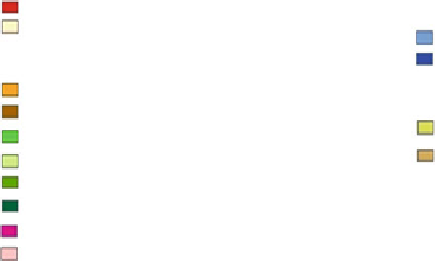
FAO_LCCS_14 - Class
Dichotomous Phase
Natural Water-bodies, Snow, And Ice
B15: Artificial Surfaces And Associated Area(s)
B16: Bare Area(s)
A1-A5-V4: Inland Water- Standing - Very Saline
A1-A4-V1: Inland Water- Flowing - Fresh
Cultivated And Managed Terrestrial Area(s)
A1-D1: Tree Crops- Rain-fed Cultivation
Natural And Semi -Natural Primarily Terrestrial Vegetation
A1-D3: Tree Crops- Irrigated Generally
A1-A14: Woody Vegetation- Sparse (20-10) %
A3-D1-S1-S0311: Herbaceous Crops- Rain-fed Cultivation- Wheat (Triticum spp.)
A3-D1-S1-S0302: Herbaceous Crops- Rain-fed Cultivation- Barley (Hordeum Vulgare L.)
A2-A24: Herbaceous Vegetation- Sparse (20-10) %
A3-D3-S1-S0311: Herbaceous Crops- Irrigated Generally- Wheat (Triticum spp.)
A3-D3-S1-S0302: Herbaceous Crops- Irrigated Generally- Barley (Hordeum Vulgare L.)
A3-D3-S1-S0702: Herbaceous Crops- Irrigated Generally- Fodder Pulses
A3-D8: Herbaceous Crops- Fallow System
Fig. 5.14 Description of the resulting 14-class for the four 4-regions sub-study-area (Source
adapted from LCCS-Software/Version 2.0)
accommodated in this highly flexible system; the classification could therefore
serve as a universally applicable reference base for land cover, thus contributing
towards data harmonization and standardization (Di Gregorio
2005
).
Included here is the general legend which generated from the LCCS-Software,
because it is difficult to read the description of the resulted classes once the legend
is integrated with the resulting thematic maps (Fig.
5.14
).
5.4 Field Work
The identification of the potential LULC-classes and the thematic content that a
classification can or should be included is crucial, where a classification process is
a thematic analysis of the landscape (Jensen
2007
). Such interpretation to be
founded, it is necessary to identify and understand factors that control and
determine the form of features or phenomena. So, field work and observations are
essential if a supervised based classification method will be used (Richards and Jia
2003
).
Interviewing local farmers provides important understanding of the general
characteristics of the LULC in the study area during the past decades. So, inter-
views were conducted with village leaders and farmers. The main reason for
interviewing these people was to find the relationship between the satellite data
and the qualitative LULC-history in the surroundings of the villages.
Field work was carried out in June, 2007 (Fig.
5.15
), since measurements can
be taken (GPS-points) for either winter and/or summer crops. Annually in June in
Syria, the wheat and barley are harvested (N.B., most irrigated wheat in east Syria
will not be harvested yet), the sugar beet will still be green, cotton and corn will
Search WWH ::

Custom Search