Geography Reference
In-Depth Information
resolution of used remote sensing data; the capability with the prior studies; the
used algorithms for image-processing and classification; and the time limitations.
A system of LULC classification categorizes the all definable LULC-features into
classes in the system. A good system should have three characteristics (informa-
tively, exhaustively and separability) (Jensen
2007
). Also, a good system structure
can be located at any point on the map/ground into one and only one LULC-
category.
An a priori hierarchical structure system for the LULC-classification for the
study area was build. This system was adopted to increase the flexibility of
classification procedures and to take different conditions into account. Further-
more, the LULC-classification system used the ''diagnostic criteria and their
hierarchical arrangement to form a class (map-ability function), that had the ability
to define a clear boundary between two classes. Hence, diagnostic criteria should
be hierarchically arranged in order to assure a high degree of geographical
accuracy at the highest levels of the classification. These prerequisites can only be
accomplished if the classification has the possibility of generating a high number
of classes with clear boundary definitions'' (Di Gregorio
2005
).
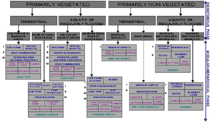
The Land Cover Classification System (LCCS) was designed with two main
phases (see Fig.
5.13
): (A) an initial Dichotomous Phase, in which eight major
land cover types were defined: (1) Cultivated and Managed Terrestrial Areas; (2)
Natural and Semi-Natural Terrestrial Vegetation; (3) Cultivated Aquatic or Reg-
ularly Flooded Areas; (4) Natural and Semi-Natural Aquatic or Regularly Flooded
Vegetation; (5) Artificial Surfaces and Associated Areas; (6) Bare Areas; (7)
Fig. 5.13 Overview of the land cover classification system (LCCS), its two major phases and the
classifiers (Source adapted from Di Gregorio
2005
)
Search WWH ::

Custom Search