Geography Reference
In-Depth Information
a spatial enhancement of the ETM+-scenes with the spatial resolution of 30 m was
required. This was conducted by transforming the data into a 15 m spatial reso-
lution using the ENVI-program and selecting the Schmidt Spectral Sharpening
Algorithm. Figure
4.4
shows the spatial distribution of the two remotely sensed
data which were used in the fusion and mosaicing process.
5.2.5 Mosaicing, Subsetting and Masking
The mosaic-process was applied to data which had similar atmospheric conditions
and no radiometric distortion overall, or to those data whose atmospheric and/or
radiometric distortions were corrected or normalized using ATCOR-2 and/or
iMAD (see
Sects. 5.2.2
and
5.2.3
). For the data which were impossible to correct,
a LULC-classification was carried out for each scene and then mosaiced to the
results, to determine statistics. These results were in turn compared with those of
the other data set (e.g., post-classification change detection) (see
Sect. 5.12.2
). The
advantages of the mosaic process were found to be their ease and the speed in
digital image processing.
Section 5.2.4
and the figures (Figs.
5.9
and
5.11
) explain the followed process
for two data sets. Figure
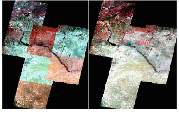
5.12
explains the difference between two generated
mosaics and the importance of the pre-processing steps, mainly color balancing,
radiometric normalization and atmospheric correction.
Fig. 5.12 Two mosaic-results of the data set (LANDSAT-TM-August-2007). Left without any
digital pre-processing steps/techniques or corrections; right after applying corrections
Search WWH ::

Custom Search