Geography Reference
In-Depth Information
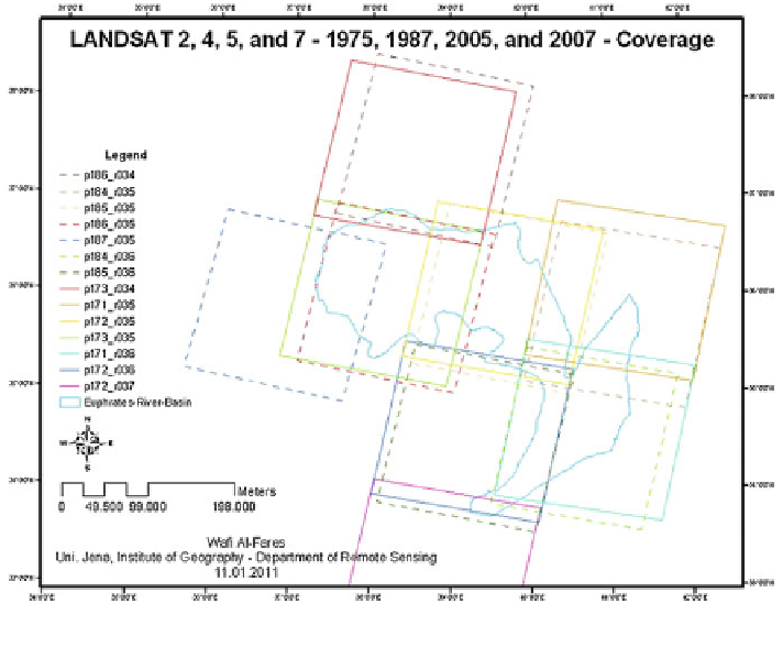
Fig. 4.2 The used imagery spatial coverage of the sensors: MSS (June, 1975), TM (May and
August, 1987 and 2007), and ETM+/SLC-Off/corrected (May and August, 2005)
resolution of 79 m (frequently, prepared to be 60 m as pixel size). Its spectral
resolution is not large enough for some studies (e.g., crops classification), where it
has four spectral bands only. These bands located within the four spectral portions
(wavelengths) with a four typical band-naming: blue (MSS-4), green (MSS-5), red
(MSS-6) (the visible spectral portion); and the Near-Infra-Red (NIR) (MSS-7).
Only the third LANDSAT hold a MSS sensor that has five spectral bands, were the
fifth one was a thermal infrared (10.4-12.6) lm. This standard is no longer used;
instead the MSS-bands are referred to the bands 1, 2, 3 and 4 respectively, con-
sistent with the TM and ETM+ sensors; (2) LANDSAT (4 and 5), which carried
the TM sensor, in addition to the MSS. This second generation offered a clear
enhancement in remote sensing through the supplement of a more advanced
sensor, enhanced gaining and transmission of data, and more rapid data processing
at a highly automated processing capability. The MSS-sensor was kept to provide
continuity with the previous LANDSAT-missions, but TM-data rapidly became
the main source of information used from these satellites because of its enhanced
spatial, spectral, radiometric and geometric characteristics in comparison to MSS-
data. Finally, the gaining was limited to real-time download only, since there were
no onboard recorders on these sensors (Chander et al.
2009
); and (3) LANDSAT (6
and 7), consisting of LANDSAT-6 which carried the Enhanced Thematic Mapper
Search WWH ::

Custom Search