Geography Reference
In-Depth Information
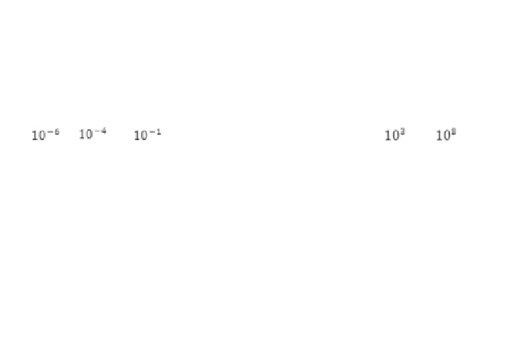
Y-ray
X-ray
Ultraviolet
Near-IR Mid-IR
Thermal-IR
Microwave
1
3
15
(µm)
Visible Bands
Blue
Green
Red
0.4
0.5
0.6
0.7
(µm)
Fig. 2.2 The primary spectral regions of the electromagnetic spectrum that are of interest in
Earth remote sensing applications (Source modified from Tso and Mather
2009
)
interpreters detect the value of these statistics by quantitatively comparing the
relation between studied class signatures and the used spectral bands. Spectral
signatures are made more sophisticated by superior ground-truth points/measure-
ments and accuracy assessment analysis. By utilizing the sophisticated spectral
signatures in multispectral classification and thematic mapping, the interpreter
generates new data for analysis (ERDAS
1999
). Figure
2.3
shows idealized
spectral reflectance plots for two types of vegetation, soils and water types,
respectively.
2.2 Remote Sensing Application in Syria
The application of remote sensing in Syria is similar to the situation which exists
in other developing countries. Remote sensing technology has been in place for
more than two decades but has lacked the expected effectiveness of such tech-
nology as used in the countries of the developed world. The General Organization
for Remote Sensing (GORS) was established by the Syrian Arab Republic (SAR)
in 1986 and is today the most important and highest scientific body in the country
competent to conduct remote sensing. It carries out many scientific projects and
studies based on the application of remote sensing in Syria, and has utilized these
skills even outside the country's borders (e.g., in Sudan). All of these studies have
been addressed to the government's institutions and ministries, and thus the basics


Search WWH ::

Custom Search