Geology Reference
In-Depth Information
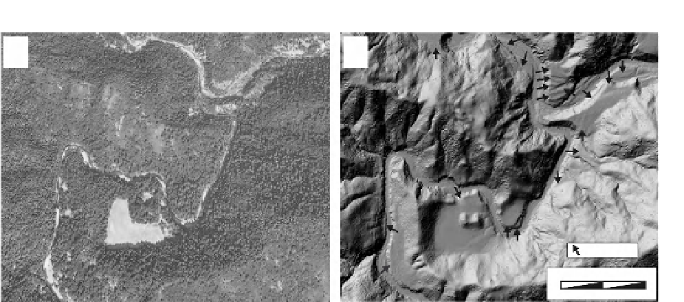
A
B
AM
AM
terraces
0
500
meters
Fig. 2.18
Lidar imaging of terraces beneath a dense forest canopy.
Paired images of about 2.5 km
2
of the Eel River catchment in northern California. A. The high-altitude photograph
depicts the dense vegetation that dominates this humid, temperate landscape and obscures the smaller-scale
topography. B. The shaded-relief DEM (1-m pixels) reveals dozens of fluvial terraces (arrows) flanking the river
banks. Flights of terraces a few meters across are clearly visible, such as at the confluence in the upper right corner.
AM: abandoned meander. Modified after images from the National Center for Airborne Laser Mapping (NCALM) and
Google Earth.
of terraces or moraines that are unrelated to the
regional sequence. Surging glaciers or ones
covered by rockfalls, for example, often advance
largely independently of climatic controls (Kamb
and Engelhardt, 1987; Santamaria Tovar
et al.
,
2008). Yet, they create moraines that are not
readily distinguishable from those of glaciers
intimately controlled by climate. Ages assigned to
those moraines based on correlation to a climatic
record would be erroneous. Similarly, a very
large landslide in a catchment may overwhelm
the transport capacity of a river (Ouimet
et al.
,
2007). This excess sediment would cause the
river bed to aggrade, and an aggradational terrace
could be left behind that is unrelated to terraces
in nearby drainages, where terraces reflect
instead the regional climatic controls.
and linear features, such as moraines. Clever
reading of the landscape and innovative
adaptations of the general principles and
approaches discussed here provide a basis for
utilizing geomorphic markers in almost any
geomorphic setting. One must attempt to
understand the pristine, undeformed shape of
the marker (formally, the initial conditions of
the problem), because this shape forms the
basis for all interpretations of deformation.
Dating of geomorphic features takes persistence,
familiarity with available techniques, innovation,
and some luck. The search for datable material
is often tedious, but as one geologist said, “If
you haven't found datable material, it's because
you haven't looked carefully enough!” All
calculations of deformation rates depend on
assigning ages to displaced features. Therefore,
those long searches can often pay off by
yielding new insights into how rapidly
deformation has occurred in the past. In the
next chapter, we examine several approaches
to dating of geomorphic, stratigraphic, and
structural features that record deformation. Just
as geomorphic markers, such as moraines,
Summary
Geomorphic markers abound within many
landscapes. Common geomorphic markers
include wave-cut benches (marine and
lacustrine), fluvial surfaces (terraces and fans),