Geology Reference
In-Depth Information
A
B
upthrown
block
down-
thrown
block
present stream
0
20
12 m
meters
fault
trace
12 m
present stream
beheaded
streams
Beheaded
Channels
1-m
contours
beheaded streams
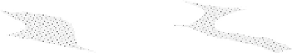
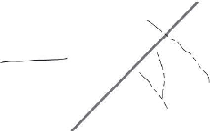
Fig. 2.16
Beheaded channels along a strike-slip fault.
A. Sketch of beheaded streams along a strike-slip fault, the Wairarapa Fault, North Island, New Zealand. Spacing
between streams indicates two previous earthquakes with about 12 m of displacement in each event. B. Map with 1 m
contours of offset and beheaded stream channels along the Wairarapa Fault. Modified after Grapes and Wellman (1993).
slope, the cause of the offset is more likely to
be tectonic than when the deflection occurs in
the direction of the regional slope. Owing to
strike-slip motions, streams can be
beheaded
,
by which it is meant that an abandoned stream
channel abruptly terminates as it crosses a fault
(Fig. 2.16B). The difficulty in assessing offsets
of rivers and ridge crests lies in making reliable
correlations from one side of a fault to the
other. Commonly, multiple ridges and streams
cut across faults, so that specific correlations
can be ambiguous (Frankel
et al
., 2007).
Because rivers are capable of incising and
modifying any displaced profile, vertical move-
ments often are underestimated by the apparent
displacement of the river channel at the loca-
tion of the fault. If the upstream part of a stream
bed is elevated by faulting with respect to its
downstream continuation, the stream will tend
to incise through the scarp. Remnants of the
former valley floor may be preserved as small
terraces on either side of the channel, and their
height above the downstream, but offset, con-
tinuation of the channel can be used to assess
the amount of vertical displacement (Beanland
and Clark, 1994).
often be readily measured in map view from
the offset of the linear trend of the moraine
crest, whereas vertical offsets can be assessed
by comparing the topographic trend along
the length of the moraine crest on either side
of a fault.
If advances attributed to surging glaciers are
excluded, then most major glacial advances
are responses to large-scale climatic changes.
Thus, one might expect to be able to correlate
the record of successive glacial advances
with the record of Quaternary climatic fluctua-
tions (see Box 2.1). For the most recent
advances, this is commonly true, although
the timing of the maximum extent of alpine
glaciers in any particular mountain range
often differs by thousands of years from the
time of maximum ice-sheet extent (Gillespie
and Molnar, 1995). Therefore, whereas an
absolute date on a moraine is always preferred,
an approximate age can be assigned to
undated moraines, and tectonic rates (with
appropriate uncertainties) can be calculated
based on observed offsets.
When moraines other than those associated
with the most recent advances are considered,
the one-to-one correlation with the climatic
record typically breaks down due to incomplete
moraine preservation (Box 2.3). In such
circumstances, a local glacial chronology
associated with specific preserved moraines
(Owen
et al.
, 2008) needs to be established in
order to have reliable control on long-term rates
Glacial moraines
The elongate ridges of ice-transported debris
that form glacial moraines provide linear geo-
morphic markers (Plate 1E) that have an obvious
direct climatic cause. Lateral displacements can