Geology Reference
In-Depth Information
Lake levels in closed tectonic depressions
fluctuate significantly in response to the water
balance in the catchment. Unfortunately,
unlike major changes in eustatic sea level,
which are essentially synchronous on a global
basis, lake-level changes (Fig. 2.8A) commonly
vary between adjacent basins (Benson
et al.
,
1990). Compilations of lake-level records from
the southwestern United States (Smith and
Street-Perrott, 1983) show that, even in a
limited geographic region, the timing of
highstands can be quite variable (Fig. 2.8B).
Such variability can result from sustained
sweeps of climatic systems across a region in
response to, for example, latitudinal shifts of
the Intertropical Convergence Zone or to
retreat of ice sheets. Temporal variability also
results at least in part from the complex
routing of water through the landscape, such
that one basin may begin to fill only after an
adjacent basin overflows (Adams
et al.
, 1999).
Once the water in a lacustrine basin fills to the
height of an outlet, the water level cannot get
significantly higher, even if the discharge into
the lake continues to increase. Conversely,
bedrock thresholds that control the level of a
lake outlet and, therefore, its maximum height
may erode and can cause the lake level to
drop, irrespective of climatic variations. These
regional and local factors dictate that the age
of a displaced shoreline must be determined
within the particular basin being examined,
rather than inferred through correlation with
dated shorelines elsewhere or with global
climate records.
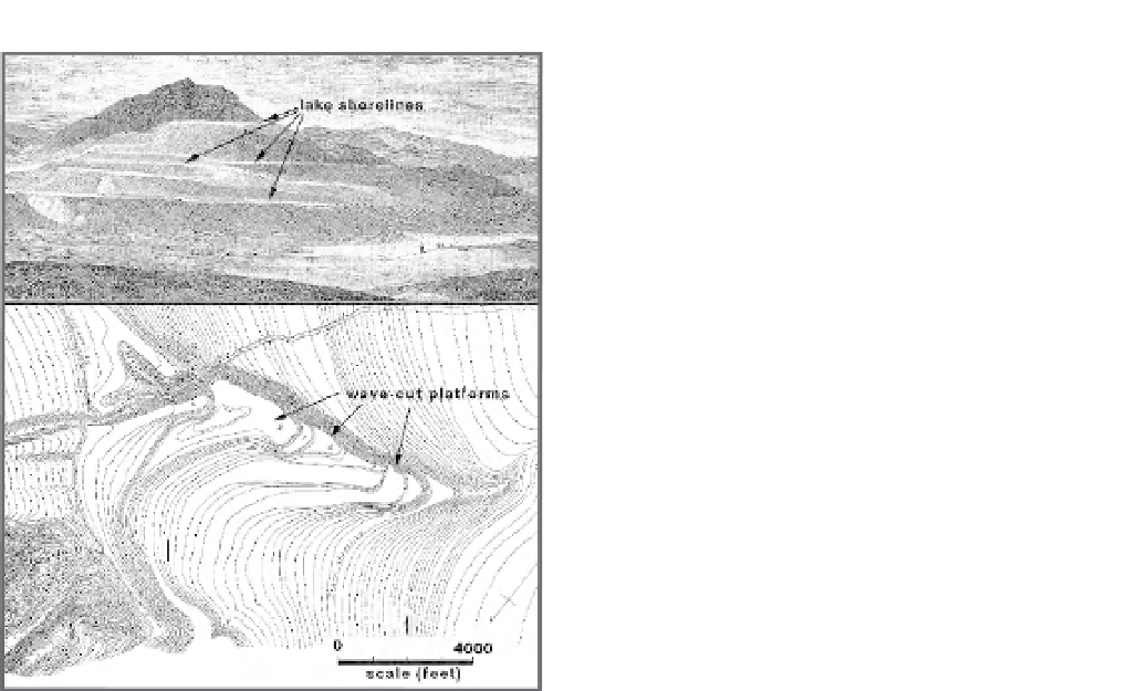
A
Lake Bonneville
Shorelines
B
Fig. 2.7
Lacustrine shorelines formed by Pleistocene
Lake Bonneville.
Wave-cut platforms are incised into headlands, the
flanks of islands, and across spits. A. Perspective view
of shorelines. B. Topographic map of wave-cut
platforms incised into an elongate spit.
Modified after Gilbert (1890).
Lacustrine shorelines
Like marine terraces, lacustrine shoreline features
are almost perfectly horizontal at the time of
their formation. As waves impinge on the shore,
they create
wave-cut benches
or
lacustrine
strand lines
. The width of these benches depends
on the erosional resistance of the bedrock at the
shoreline, the length of time during which the
lake level remained constant, and the strength of
wave attack, which is a function of fetch, storm
winds, and local shoreline geometry. Along the
margins of Pleistocene Lake Bonneville in Utah,
for instance, benches as much as 100 m wide
have been formed. In Gilbert's (1890) pioneering
study on Lake Bonneville, he identified many
of these shorelines and used them as markers
to document crustal rebound that followed the
shrinkage of the lake (Fig. 2.7).
Deltas
Both marine and lacustrine deltas provide clear
geomorphic evidence for former water levels.
Deltas have an advantage over terraces or wave-
cut benches in that they are often larger
geomorphic features that are therefore more
likely to be preserved. The disadvantage of
deltas is that they only form where rivers enter
bodies of water, and thus they typically offer
less extensive spatial coverage than do shoreline
features: they provide control on changes in
elevation at a point, rather than along a line.