Geology Reference
In-Depth Information
components have developed significantly to
acknowledge the operation of specific processes
in the face of more complete distributions of
atmospheric and oceanic events. Glacial models
have evolved to fill in the gap at high elevations
accessed by the highest of our mountain ranges.
Importantly, new models are beginning to
couple landscape evolution models both upward
and downward as they incorporate both atmos-
pheric and mantle feedbacks.
As we have tried to illustrate, considerably
more cross-over now exists between relevant
research fields: Atmospheric scientists have
become more interested in the rich interac-
tions between topography and the atmos-
phere. Thermochronologists are now teaming
up with landscape modelers and geophysicists
specializing in thermal problems to develop
models that predict the thermal evolution
of rocks that emerge at the surface. Geo-
dynamicists with models of mantle flow are
now calculating the impacts of such flowfields
on the Earth's surface elevations. The resulting
models are now capable of predicting the spa-
tial and temporal patterns of a variety of meas-
urable quantities. Old data sets can now be
evaluated - see, e.g., Braun's (2005) re-evaluation
of House
et al.
's (1998) He age pattern in the
Sierras. Just as importantly, however, such
models can be and should be used to inform
better strategies for collection of new data in
the field. Given the high expense of both col-
lecting samples and making the measurements
of, say,
10
Be or (U-Th)/He, it behooves the
tectonic geomorphologist to make use of
these models so that the samples that are
collected can exert maximum leverage on our
knowledge.
Significant challenges remain in developing
strategies to handle the huge discrepancies
between (i) time scales and length scales at which
real geomorphic processes act and (ii) those at
which landscapes evolve significantly enough
to alter either atmospheric or geodynamic pro-
cesses. Whereas great excitement understandably
surrounds applications of weather-scale models
in landscape evolution, at present these models
cannot encompass enough geological time to fill
out the full probability of storms that the climate
Dynamic Topography of the Colorado Plateau
1.2
Active Up-
welling
Sites
a
GC
b
spatial
lag
0.8
no (M1)
yes (M2)
0.4
period
of
rapid
uplift
0
Colorado
Pl
ate
au
-0.4
period
of
rapid
uplift
b
GC
a
-0.8
SW
NE
100
80
60
40
20
0
Age (Ma)
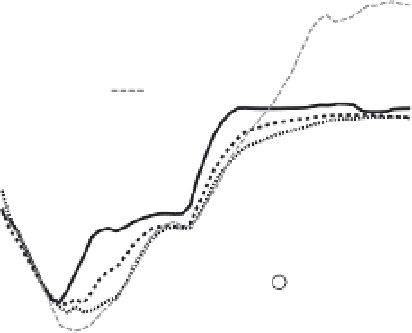
Fig. 11.30
Modeling the uplift history of the
Colorado Plateau.
Results of models of the dynamic topography associated
with passage of the Farallon slab beneath western North
America. The topographic effects of active mantle
upwelling are incorporated only in the second (M2).
Histories of three sites (shown in inset map centered on
Colorado Plateau) reveal early subsidence of 600-800 m,
followed by two-stage uplift, with periods of maximum
rate of uplift shaded. Notably, these models predict little
change in elevation over the past 20 Myr. Lags between
sites (heavy arrows) indicate a northeast-migrating wave
of Cretaceous to Cenozoic subsidence and uplift in
response to mantle slabs and suggest tilting of the surface
through time. Modified after Liu and Gurnis (2010).
explaining the complex temporal-spatial
elevation history across the Colorado Plateau
(Flowers, 2010). Together, these studies both
advertise the role of mantle flow models in
addressing elevation histories of broad regions,
and call for more corroborating evidence in
the form of paleoelevation histories in such
enigmatic regions.
Present limits and the next generation
of models
The progress made by the community in the last
decade has been tremendous. Many of the defi-
ciencies identified in the past have been
addressed. Coastal, river, and hillslope evolution