Geology Reference
In-Depth Information
nicely summarized bedrock rivers, the processes
responsible for their erosion, and some modeling
approaches that have been taken to address these.
We advertise only a few such studies here.
Modeling Strath Terraces
A
1
Sediment flux
Floodplain width
Vert./lateral rates
Terrace incision
0
400
300
200
100
0
Fluvial strath terraces
Model time (ky)
Residence time (ky)
As discussed in Chapter 2, whereas marine
terraces are distinct elevational datums, strath
terraces cut by rivers record the vertical and hor-
izontal position of a river. The height of a dated
strath above the modern river has been used to
constrain the mean vertical incision rate of the
river. But the specific processes responsible
for the formation and abandonment of a strath
or a suite of straths have been less frequently
addressed. The conceptual model for this
sequence is set out in Fig. 2.12 and is discussed
further in Chapter 7 (see Fig. 7.13). Strath ter-
races are formed by alternation of vertical inci-
sion of a river into bedrock to abandon one
strath, and lateral planation of the river to widen
the next strath. In the “sediment loading model,”
it is crucial to be able to model the river's
response to temporal variations of the sediment
supply. Using the set of 15 distinct terraces
along the present Wind River in Wyoming as
their inspiration, Hancock and Anderson (2002)
attempted to capture the essence of the strath
problem in a numerical model. Acknowledging
that this system has glacial headwaters, they
modulated both sediment and water delivery to
the channel at its upstream end. Both vertical
incision and horizontal incision were allowed.
Crucially, when the alluvial cover of the channel
is greater than a prescribed scour depth thresh-
old, the river cannot access the bedrock beneath
it and vertical incision is disallowed. On the
other hand, bedrock is still available to incise
laterally, and the river can widen its floodplain,
etching a strath. If, for some reason, the alluvial
cover thins to allow vertical incision into bed-
rock, the strath is abandoned. The model results
are summarized in Fig. 11.12.
They found that the stronger control on
formation and abandonment of straths was mod-
ulation of sediment supply in the headwaters. In
glacial settings, sediment supply is likely to vary
many-fold as the footprint and erosivity of the
60
50
40
30
20
10
0
2750
B
2650
Channel-elevation
history
Strath-terrace
cutting intervals
2550
2450
1500
1000
500
0
Distance from present channel (m)
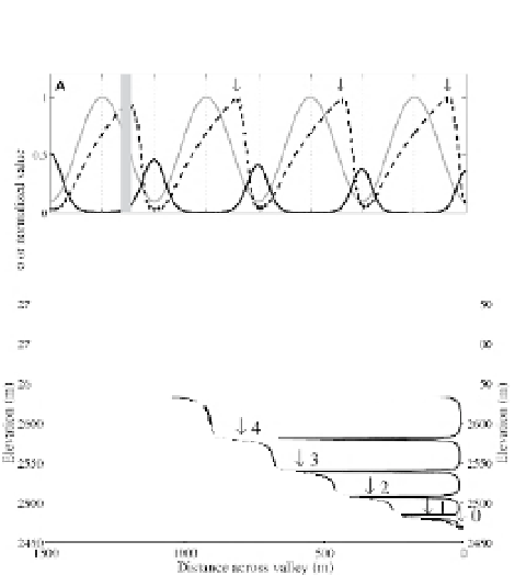
Fig. 11.12
Modeling strath terrace sequences.
A. History of normalized sediment inputs (solid gray
line), normalized valley-floor width (i.e., floodplain
width) at river level (dashed line), and the ratio of
vertical to lateral erosion rates (solid black line)
during a simulation with a 10-fold variation in
sediment supply at a 100-kyr periodicity. Inputs and
valley-floor widths are normalized by dividing the
value at each time by the maximum value during each
simulation. The valley floor, i.e., the “floodplain,”
widens most significantly when vertical erosion rates
are low, producing a ratio of vertical to lateral erosion
that is small or zero. Floodplains are abandoned to
form terraces when vertical erosion rates and the ratio
of vertical to lateral erosion rates increase, leading to
renewed downcutting and narrowing of the active
valley. Terraces are formed at the transition (arrows)
from valley-floor widening to narrowing that
represents channel incision. Terrace formation does
not occur at the times of either maximum inputs or
minimum inputs, but instead significantly lags the
timing of maximum sediment supply. In the si
mulations, all terraces generated are strath terraces.
B. The topographic profile (thick gray line) and
channel residence time as a function of elevation
during downcutting in this simulation (thin black
line). Terraces are related to periods of lateral
planation during long channel residence within a
narrow elevation range. Residence time at individual
terrace levels reaches up to many tens of thousands
of years, indicating that the river spent most of the
simulation forming terraces. Modified after Hancock
and Anderson (2002) and Anderson and
Anderson (2010).