Geology Reference
In-Depth Information
glacial
erosion
Glacial versus
Fluvial Erosion
Proiles
glacial
proile
contrasting
erosion
luvial
erosion
luvial
proile
Bedrock
A
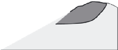
Fig. 10.41
Fluvial versus glacial erosion.
A. Cartoon of generalized long profiles for
valleys with and without former glaciers in
their headwaters. The glaciated valley is
typified by a break in slope to a much gentler
gradient in its upper reaches. This low-
gradient zone delineates the contribution from
glacial erosion that is absent in a catchment
that lacks former glaciers. B, C. Examples of
fluvial versus glacio-fluvial valleys from the
Kyrgyz Range, where an unconformity surface
serves as a geomorphic marker against which
to calibrate erosion. The point of deepest
incision moves up-valley and is significantly
deeper for the more glaciated catchments.
The fluvial parts of the valleys are pipe-like:
uniform width along their length. Such
uniformity is not uncommon when parallel
drainages develop on steep slopes. Large-scale
widening of the valleys occurs within their
glacial portions. Modified after Oskin and
Burbank (2005).
Fluvial versus Glacial Valley Depth
B
unconformity
surface
glacial deepening
2
fluvial only
1
point of
deepest incision
0
fluvial only
:
pipe-like
Fluvial versus Glacial Valley Width
2
0
glacial
widening
0
5
4
2
0
pipe-like
C
0
5
6
4
2
0
pipe-like
0
5
10
Distance (km)
catchments are compared, one that was glaciated
in its upper reaches and one that was not, the
shape of the fluvial parts of the long profile of
each valley will match, but the upper part of the
catchment that once held a glacier will show
a significant drop in gradient in comparison to
the equivalent part of the non-glaciated valley
(Brocklehurst and Whipple, 2002). The gradient
change represents a divot of bedrock that was
removed by the glacier, but whose equivalent
was not eroded by the river system in the adja-
cent valley (Fig. 10.41A). Geomorphic studies
of glaciated valleys for which a reference frame
exists, such as a pre-existing erosion surface
(Oskin and Burbank, 2005; Small and Anderson,
1998), show very efficient headwall retreat and
valley widening by glaciers in comparison to
nearby fluvial valleys (Fig. 10.41B and C).
The second observation that supports the
greater or equal celerity of glacial erosion
compared to rivers is the fact that, in many rap-
idly eroding ranges, even though glaciers are at
the smallest size that they have been for perhaps
nearly a million years, they rest in the bottom of
deep, steep-walled, high-relief, and typically low-
gradient valleys that could only have been carved
by ice in the past, given the currently retracted
size of the glaciers. Compared to nearby river
valleys, the previously glaciated valleys almost
always sit lower in the landscape, a testament to
the efficiency of glacial erosion in the past.
Whereas glaciers may erode as fast as or faster
than rivers, these rates are only true for temperate
or warm-based glaciers that are sliding on their
beds because they are at the pressure-melting
point. Cold-based glaciers deform internally, but
do not slide. As a consequence, they do not erode
the bedrock beneath them, and no glacial buzzsaw
exists where the glaciers are frozen to their beds.
Steady-state topography assumes a different
form and time scale in rapidly uplifting ranges
that are sufficiently high to contain cold-based
glaciers (Fig. 10.42). For example, peaks mantled
by cold-based glaciers do not erode. Instead,