Geology Reference
In-Depth Information
Glacial Valley Proiles
Mean Elevation
37˚N
37˚N
G
steep
small glacier
4755
4755
gentle
large glacier
K
deglaciated
zone
4601
4601
3973
3973
RH
4081
4081
A: Rapid Rock Uplift
3222
3222
SN
gentle
small glacier
GS
4087
4087
gentle
large glacier
deglaciated
zone
3774
3774
NP
DD
D
4290
4290
35˚N
35˚N
B: Slow Rock Uplift
Mean Snowline
37˚N
37˚N
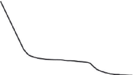
Fig. 10.39
Glaciated topography as a function of
rock-uplift rate.
Glacial valley profiles resulting from average Quaternary
conditions:
∼
400 m of snowline lowering. A. Glacial
valley profiles under rapid rock-uplift regimes. Both
headwall relief and the gradient of small glaciers increase,
whereas large glaciers retain their low gradients.
B. Under slow rock-uplift regimes, both large and small
glaciers have gentle gradients and headwall relief is
modest. Modified after Brocklehurst and Whipple (2007).
rapid rock uplift include significant increases in
the height of cirque headwalls, a modest rise in
mean elevation (due largely to the headwall
lengthening), and a steepening of moderate- to
small-sized glaciers (Fig. 10.39).
Even in rapid uplift zones, large glaciers
retain low gradients, suggesting that they erode
effectively irrespective of rock-uplift rate. At
least two factors could serve to enhance glacial
erosion in regions of rapid rock uplift. First,
these areas often contain very high peaks, even
if the mean elevation is not particularly high.
Such peaks have been termed “topographic
lightning rods” because of their role in causing
more precipitation on their flanks (Brozovi ´
et al
., 1997). Greater ice fluxes should lead to
more rapid erosion. Second, although one's
eyes are attracted to the high summits, only a
few percent of the total topography will
typically occupy the upper 10-20% of the range
in elevation. For example, in the Himalaya, our
35˚N
35˚N
0
50
100 km
Snowline Elevation (m)
<4600
<4800
<5000
<5200
<5400
<5600
>5600
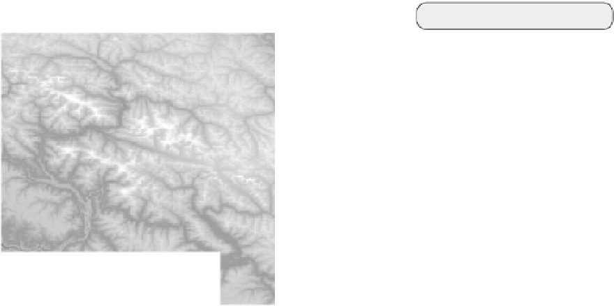
Fig. 10.38
Mean elevations and mean snowlines in
the northwest Himalaya.
(Top) Mean elevation (meters) of subregions in the
northwest Himalaya. D: Deosai Plateau; DD: dissected
Deosai; NP: Nanga Parbat; RH: Rakaposhi-Haramosh;
SN: Skardu north; K: Karakoram; G: Ghujerab. (Bottom)
Elevation of modern snowline in the same region as
shown above. Note that snowlines also rise toward the
northwest and generally lie
∼
700-1000 m above the
mean elevations. The topographic and snowline
gradients trend at nearly right angles to the tectonic
gradients in this region (Fig. 10.28). Modified after
Brozovic´
et al
. (1997).