Geology Reference
In-Depth Information
Pacific
Ocean
Pacific plate
S Fran
Los Ang
North
American
plate
100 km
San Andreas
fault
N
San Andreas
Fault System
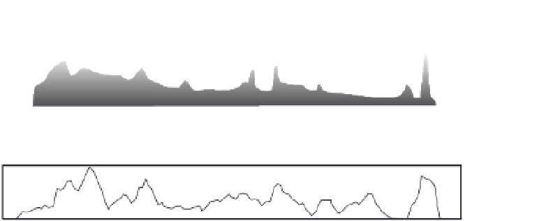
Fig. 10.34
Topography,
dynamics, and rainfall along
the San Andreas Fault
system.
Along
∼
1000 km of the San
Andreas system in California,
obliquity of the fault trend with
respect to directions of plate
motion defines transpressional
and transtensional regimes.
Other data are averaged from
an 80-km-wide corridor
centered on the fault. Rock-
uplift rates are derived from
thermochronological data and
an estimated surface-uplift rate.
These rates generally correlate
with stronger transpression and
higher elevation. Modified after
Spotila
et al
. (2007).
40
S
N
Transpression
(+)
20
0
-20
Transtension
(-)
10
1
0.1
S
Rock-Uplift Rate
N
S
Elevation
N
1
0
20
S
Slope
N
10
0
S
N
N
0.2
0.
1
Precipitation
0
600
1000
0
200
400
800
Along-Strike Distance (km)
length of the fault show that the higher rock
uplift rates, steeper slope angles, and higher
elevation tend to correlate with higher rates of
transpression, whereas rainfall appears largely
inversely correlated with elevation (Spotila
et al
., 2007) - the opposite of the common
linkage of orographic rainfall to topography.
In general, climate appears largely decoupled
from local topography and tectonics along this
very active strike-slip system.
The Andes traverse 60
Latitudinal gradients in climate
and tectonics
Elongate, north-south oriented ranges can span
latitudinal bands with contrasting climate
regimes. Prevailing winds can change from
easterly to westerly flows, the wet side of a range
may switch from east to west, and local climates
can vary from desert to rainforest conditions.
The Cordillera of the Americas provides the best
modern examples of ranges that span broad
latitudinal zones. Hence, it is reasonable to ask
which aspects, if any, of tectonic, topographic,
and climatic trends correlate along these ranges.
One might expect that along strike-slip faults,
correlations between climate and tectonics
would be weak. In fact, along the San Andreas
Fault in California, tectonics appears more
important than climate in driving topographic
change (Fig. 10.34). Data averaged along the
of latitude, which
includes several climate zones dominated by
either easterlies or westerlies. The western flank
of the Andes encompasses both tropical
rainforests and hyperarid deserts. Despite the
overall continuity of subduction beneath the
western Andes, we might expect major, along-
strike differences in sediment fluxes, erosion
rates, and perhaps tectonics as a result of this
climate zonation. A recent synthesis of Andean
°