Geology Reference
In-Depth Information
Topographic Controls on Himalayan Rainfall
8
A
One-step topography
B
Two-step topography
6
elevation
elevation
rainfall
rainfall
4
one rainfall
peak
two rainfall
peaks
2
0
0 100 200
South-North Distance (km) South-North Distance (km)
300
0
100
200
300
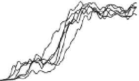
Fig. 10.32
Topographic controls on monsoonal rainfall in the Himalaya.
Topographic and rainfall data are compared from swaths that are 300 km long and 50 km wide, with the long axis
oriented perpendicular to the strike of the range. Data for either rainfall or elevation are averaged across each
50-km-wide swath. A. Data from six swaths in which topography rises steadily from the lowlands to the high peaks.
A single peak of high rainfall occurs near the front of this topographic ramp. B. Data from six swaths in which
topography rises in an initial low step (1-2 km high) followed by a larger step (2-4 km high) farther into the range.
Monsoon rainfall produces a peak associated with each topographic step. Note that the total amount of rainfall in
each swath is about equal, but its spatial distribution depends strongly on topography. Modified after Bookhagen
and Burbank (2010).
decade of remotely sensed rainfall throughout
the Himalaya. For example, along the southern
Himalaya, monsoon rainfall commonly displays
either a single, range-parallel band of high rain-
fall or two such bands (Bookhagen and Burbank,
2006) (Plate 10). Analysis of the topography asso-
ciated with these single or dual bands of rainfall
reveals two clear end-members (Fig. 10.32) that
relate broad topographic characteristics to rainfall
patterns. In particular, where the range-front
topography rises as a steadily climbing ramp, a
single peak of high rainfall exists. In contrast,
where the Himalayan front is defined by two
topographic steps (generally separated by a
broad expanse of Lesser Himalaya of nearly uni-
form altitude), two bands of high rainfall prevail.
Contrary to some expectations, zones of high
rainfall commonly do not spatially coincide with
the highest topography. Instead, these zones are
typically offset upwind of a range crest by several
to many kilometers, particularly for the unusually
high topography of the Andes and Himalaya.
In fact, given the typical moisture and wind
conditions, the peaks of high rainfall can be
confined to rather discrete altitude ranges that
may lie several kilometers below the height of the
summits that define the range crest (Fig. 10.33).
Himalayan Orographic Rainfall
3
inne
r r
a
i
nfall peak
2.1±0.3 km
±2
σ
2
1
±2
σ
0.9±0.4 km
outer rainfall peak
0
0
1
2
34 56
Mean Annual Rainfall (m/yr)
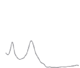
Fig. 10.33
Elevation control on peaks of Himalayan
monsoon rainfall.
Along the southern Himalayan topographic front, peaks
of high rainfall typically lie within discrete altitudinal
bands. Commonly, these peaks are offset many
kilometers upwind of the highest topography and lie
several kilometers upwind of the topographic steps that
drive the rise, cooling, and condensation of moist air
masses that produce these peaks (see Fig. 10.32).
Modified after Bookhagen and Burbank (2006).