Geology Reference
In-Depth Information
end-members (Fig. 7.3B and C): at lower erosion
rates, slope is linearly proportional to the erosion
rate, whereas at higher erosion rates, slope is
largely independent of the rate, as would be
expected if threshold slopes were prevalent.
To assess whether a landscape more closely
mimics one end-member or the other, it is
necessary to document the spatial variation in
rock uplift, denudation, and slope angles. A good
case study emerges from the northwest Himalaya
in the vicinity of Nanga Parbat, where some of
the greatest relief on Earth is found: across a
distance of about 20 km, over 7 km of relief occurs
between the Indus River and the summit of
Nanga Parbat. Thermochronological studies in the
vicinity of Nanga Parbat (Zeitler, 1985) document
greater than 10-fold differences in bedrock
cooling rates and inferred long-term denudation
rates. These rates appear to vary systematically
across the region (Fig. 10.29). As described
previously (Fig. 7.14), short-term bedrock incision
rates by rivers show a similar spatial pattern of
denudation (Burbank
et al
., 1996b). Based on
a 90-m DEM, average hillslope angles can be
defined (300 × 300 m moving windows were used
here) and then compared between areas of very
rapid versus slower denudation. Histograms of
the slope distributions (Fig. 10.30A) show a
remarkable similarity among these mountainous
regions even though they differ by factors of 3-5
in erosion rates (Burbank
et al
., 1996b). The mean
slope angle for each of these areas is 32
°
±
2
°
, an
angle similar to the angle of repose in dry
non-cohesive materials. In the context of the
fractured bedrock and the very large hillslope
lengths that characterize this region, these slopes
can be interpreted as threshold slopes in which
the slope angle is generally independent of
denudation rate (Fig. 10.28).
1-6
My
0-1
My
1-6
My
6-15
My
74°
75°
R
Ka
ra
36°
36°
H
*
N
*
NP
2-4
mm/yr
< 2
mm/yr
8-10
mm/yr
35°
35°
30 km
faults
peaks
apatite cooling ages
denudation rates
Differential
Erosion Near
Nanga Parbat
1-6 My
8 mm/yr
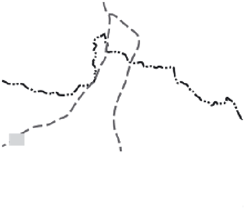
Fig. 10.29
Nested cooling ages in the northwest
Himalaya near Nanga Parbat and the Indus River,
northern Pakistan.
Based on numerous apatite fission-track ages (Zeitler,
1985), specific ranges of ages delineate a nested suite
of cooling zones. The north-south zone centered on
Nanga Parbat (NP) and Haramosh (H) cooled below
approximately 110
°
C within the last 1 Myr. Ages get
progressively older farther from this central zone of
young ages. Spatial variability in long-term cooling rates
is approximately matched by spatially variable incision
rates (given in mm/yr) derived from dating of strath
terraces (see Fig. 7.14). Each cooling and incision rate
varies by about 10-fold. Peaks over 7500 m in the area
include Nanga Parbat, Haramosh, and Rakaposhi (R).
MMT: Main Mantle Thrust (equivalent to the Indo-Asian
suture). Modified after Burbank
et al
. (1996b).
in which they suggested that accelerated late
Quaternary erosion in mountain belts would
have generated a geophysical response whereby
mass removal due to erosion would impel iso-
static uplift of the eroded regions (Fig. 1.6).
Whereas the Molnar and England (1990) model
dealt primarily with the motion of rocks in a
vertical domain, some more recent climate-
tectonic models have also emphasized widening
or narrowing of self-similar orogens in response
to decelerating or accelerating erosion, respec-
tively (Meade and Conrad, 2008; Stolar
et al
.,
2007; Tomkin and Roe, 2007; Whipple and
Meade, 2006) (Fig. 10.2). In most cases, the
Climate and tectonics
From a geophysical perspective, we might
expect that enhanced rates of erosion that result
from climate changes could change the patterns
and rates of deformation. Such climate-tectonic
linkages could take many forms. One such
proposal was that of Molnar and England (1990)