Geology Reference
In-Depth Information
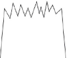
Non-Steady State: Changing Relief
mean elevation
high-frequency,
low-amplitude
relief
low-frequency,
high-amplitude
relief
plateau
A
Non-Steady State: Changing
Mean Elevation
topographic
relief
mean elevation
reference
surface
increasing relief,
increasing mean
elevation,
constant local
base level
constant relief,
increasing mean
elevation,
increasing local
base level
B
Fig. 1.8
Steady-state versus
non-steady-state topographic
characteristics.
Non-steady-state topography can
have (A) constant mean elevation,
but changing topographic relief, or
(B) constant relief, but changing
mean elevation. In steady-state
conditions, (C) relief, mean
elevation, and base level remain
constant, although the elevation of
an individual point can vary
through time.
Steady State Topography
constant relief, constant mean elevation, constant
local base level
C
cycle are needed. This integration requires clever
ways to measure quantities of material removed
from or added to a landscape. Moreover,
researchers must somehow inject a reliable
“clock” into the rock record, because rate
calculations can be no more precise than the time
interval across which they are measured. Such
measurements are difficult to make. An alternative
approach would be to determine the operational
“rules” by which various surface processes erode
the landscape, and to incorporate them into a
theoretical model of landscape evolution. For
example, how does the rate of bedrock erosion at
the base of a glacier relate to the speed at which
the glacier is sliding, its thickness, the steepness
of its bed, freezing and thawing at the ice-rock
interface, and the resistance of the bedrock
beneath it? Only if we can both define these rate
relationships and determine how glaciers have
extended and retreated in the past, will we be
able to model the mean rates of erosion within
this portion of the landscape.