Geology Reference
In-Depth Information
of geomorphic processes and with paleoseismic
analysis, it may be possible to develop more
realistic models of fold development and
erosional modification that span from decades
to many thousands of years.
The fault-bend fold developed above the
Main Frontal Thrust in central Nepal (Fig. 7.25C)
provides a well-calibrated setting for examining
how rocks that experience rapid lateral advection
(
A
A
40
35
30
Volumetric
Erosion
forelimb
25
20
15
D
10
B
A
polygon
backlimb
5
C
E
∼
20 mm/yr) are eroded as they are uplifted.
One intriguing prediction is that topographic
features can also be advected across a fold
(Miller and Slingerland, 2006; Miller
et al.
, 2007).
Observations that support this prediction include
the fact that a high proportion of valleys and
saddles in the topography are aligned from one
side of the fold to the other across the fold crest
(Fig. 9.28A and B). This alignment suggests that
northward-draining river valleys that formed on
the hinterland flank of the fold are advected
across the fold crest and become southward-
draining valleys on the distal (foreland) flank.
Numerical modeling of landscape evolution in
the context of rapid lateral advection of rocks
(Miller and Slingerland, 2006; Miller
et al.
, 2007)
predicts that such alignment of valleys should be
common for major topographic elements, such
as ridges and valleys, when advection rates are
rapid compared to erosion rates (Fig. 9.28C and
D). Whereas topographic advection on these
frontal folds is predicted to occur at scales of a
few kilometers and
0
0
100
200
300
400
500
Age (10
3
yr)
20
B
B
A
15
Slope-Dependent
Erosion
D
10
E
C
A
polygon
5
0
0
0.05
0.1
0.15
0.2
Mean Erosion Rate (m/yr)
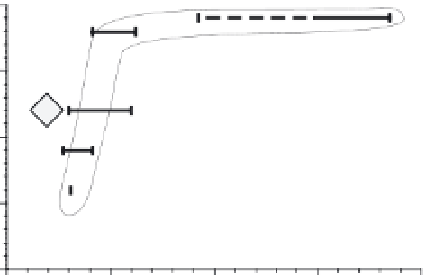
Fig. 9.27
Quantified erosion on Wheeler Ridge
anticline.
A. Eroded volume per unit area plotted versus the age
of the dissected surface. Note increasing rates with age
and persistently higher rates on the forelimb for each
age grouping. Polygons are the same as those shown in
Fig. 9.26. B. Mean erosion rate versus slope angle in
each polygon. Modified after Brozovic
et al.
(1995).
∼
10
5
years, larger features
such as deep river gorges may also be advected
at longer time scales (Koons, 1995).
predictable increases in rates for increasingly
steep slopes. The abrupt increase in erosion rate
for slopes
Fault behavior
>
°
probably does not indicate some
threshold slope angle, but rather that the longer
slopes, greater relief, and more areally extensive
gully headwalls in the older part of the fold have
promoted more rapid erosion there.
This analysis of Wheeler Ridge highlights
some of the ways in which ages on uplifted
surfaces, recognition of structural geometries
and geomorphic patterns, and quantification
using digital topography can be used to
develop a fuller understanding of the rates of
fold growth and dissection over thousands of
years. If combined with field measurements
17
Propagating versus fixed faults
Age-calibrated data on displacement profiles
gathered at intermediate scales can serve to
discriminate between faults whose tips are
propagating and those whose tips are fixed
(Fig. 9.29). In a broad sense, the shape of the
overlying fold might show little difference as a
function of whether the fault tips are fixed or
propagating (Fig. 9.1), although fixed-tip folds
are expected to have steeper displacement
gradients near their tips than do steadily