Geology Reference
In-Depth Information
within each of the Tien Shan basins. Most of the calibrated slip rates span the past 14-15 kyr (see
Fig. 2.13), but some extend to
>
100 ka. One striking result of Thompson
et al.
is study is that the
cumulative geological rates, when plotted versus the geodetic data across the same area
(Abdrakhmatov
et al.
, 1996), provide a good match to the geodetic rates (see figure B). This match
suggests that, at least at time scales of several millennia, geodetic and geological rates are equiva-
lent in the Tien Shan. This distributed deformation in the Tien Shan at geological time scales may
be relevant for other orogens that comprise multiple fault-bounded ranges and lack an underlying
megathrust. When Thompson
et al.
's (2002) study was published, it was the first to provide cali-
brated slip rates across an entire contractional orogen that encompasses complex fault patterns.
stands
∼
700 m high. Based on a fault-bend fold
model, the facet records
∼
1.1 km of slip (about
equal to the length of the fold scarp) on the
underlying thrust fault (Fig. 9.17B). Along
strike on the Quilitak fold, multiple facets rise
to parallel linear ridge crests that display
accordant heights and are nearly 4 km long
(Fig. 9.17C and D). A surface fit to these ridge
crests is interpreted to represent the uplifted
erosion surface.
A
Fold Scarp Kinematics
fold scarp
displaced terrace surface
dip of
fold scarp
φ
original terrace surface
α
angular change in ramp dip
C
Fold Scarp Dip
θ
1
70
B
T3
α
= 70°
α
= 50°
α
= 30°
Displacement
Through Time
60
50
40
T2
30
20
T1
10
α
= 10°
0
010
Dip of Lower Bed (
θ
1
)
20 30 40 50
river level at T1 to T3
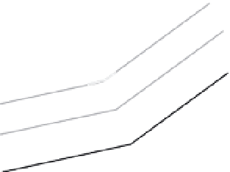
Fig. 9.16
Fold scarp kinematics and progressive terrace deformation.
A. Model for formation of a fold scarp in a fluvial terrace. The underlying fault has two planar segments that are
separated by an active axial surface. Displacement is parallel to the underlying fault for material on either side of the
axial surface (slip vectors). Terrace created at the dashed line will form a fold scarp whose length approximates (but
underestimates) the fault slip since the terrace was formed. Modified after Thompson
et al.
(2002). B. Cartoon depicting
three terraces that formed at different times at the same river height (dashed line). Length of the fold scarp approximates
the slip for each terrace. Displacement pattern is based on the fault geometry of part A. C. Fold scarp dip (
f
) as a
function of the dip of the gentler dipping fault plane (
q
1
) and the angle (
a
) between the fault planes on either side of the
axial surface. Modified after Chen
et al.
(2007).