Geology Reference
In-Depth Information
A
Long Valley Caldera Uplift: 1979-1982
i
resurgent
dome
ii
Mammoth
Lakes
t
Crowley
Lake
0
5
uplift contours (mm)
km
B
inner, underfit meander belt
Displaced Meander Belts
outward
tilt
inner
meander belt
underfit
channel
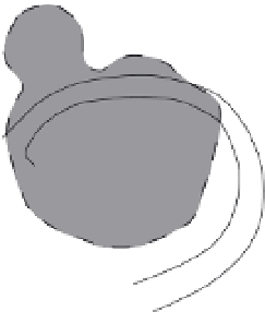
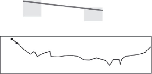
Fig. 8.25
Owens River dome.
A. Map of recent deformation
(1979-83) of the resurgent dome of
Long Valley caldera and the course of
the Owens River, showing locations
of cross-sections (i) and (ii).
B. Photographic sketch showing
parallel meander belts of the Owens
River, but with an underfit stream in
the inner belt that is closer to center
of the uplifting resurgent dome.
C. Topographic cross-sections
showing the mean slope between the
inner and outer meander belts.
Projections of these slopes toward
the dome's center suggest the
cumulative magnitude of recent uplift
(15-35 m). Modified after Reid (1992).
outer meander
belt
outer meander belt
C
2
s
ection i
B
Tilted
Flooplain
modern belt A
1
slope =0.0022
out
in
0
300
400
0
100
200
distance (m)
3
section ii
slope =0.0014
B
2
belt D
modern belt A
1
channel belts
inboard
outboard
0
0
300
400
500
600
100
200
Distance (m)
symmetry along the basin center) can be used to
infer tilting (Cox, 1994). A consistent bias of the
position of the active meander belt with respect
to the basin's mid-line can indicate tilting in the
direction of bias. The relative position of the
meander belt can be quantified as
=
T
d
O
/d
L
(8.8)
where d
O
equals the distance of offset of the
mean river course or meander belt from the mid-
line and d
L
equals the distance to the mid-line
from the drainage divide defining the basin