Geology Reference
In-Depth Information
River Concavity Crossing a Growing Fold
crestal uplift rate
river profile
perpendicular to
uplift gradient
river profile
parallel to
uplift gradient
Cross
Section
ced
ent river
lank
uplift rate
A
Channel Profiles
0.0
θ <
θ ∼
0.5
θ >
0.7
Map view
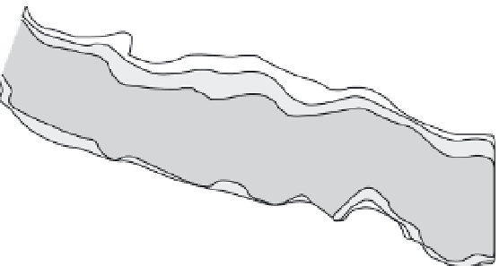
Fig. 8.24
Effects of active fold growth
on river concavity.
A. Schematic cross-section of an active
fold with a strong uplift gradient (2 mm/yr
at the flanks to 10 mm/yr at the crest).
Three classes of rivers are depicted:
(i) high-concavity rivers flowing from high
to low uplift rates; (ii) normal-concavity
rivers flowing parallel to fold axis; and (iii)
antecedent rivers. B. Schematic map view
illustrating typical concavity for the three
classes of rivers above. C. Example of
rivers crossing a very rapidly deforming
fold in the Himalayan foreland of central
Nepal. Uplift data from Lavé and Avouac
(2000). Uplift map modified after Hurtrez
et al.
(1999). Concavity values from Kirby
and Whipple (2001).
θ ∼
0.5
B
Concavity (
θ
)
0.7
0.7
θ >
θ <
0.0
θ >
Bakeya
River
Himalayan Foreland Fold
0.5
Concavity (
θ
)
1.5
0.3
0.5
0.7
0.5
1.3
1.1
1.0
2.1
-0.6
0.4
1.4
0.9
0.5
Uplift Rate (mm/yr)
1.3
4-5
5-7
1.1
7-9
9-12
1.0
C
>12
the outer belt (Fig. 8.25C). This configuration has
been interpreted to result from systematic, out-
ward avulsion of the Owens River in response to
outward tilting of the volcanic dome (Reid, 1992).
The most recent avulsion event occurred between
1856 and 1879. Because doming progressively
lowers the outer part of the floodplain with
respect to the inner part, the river will tend to
avulse into this lower, outer region during flood-
ing events. The inner belt is not fully abandoned
by the Owens River, but it retains only a fraction
of its previous discharge. Consequently, the rem-
nant channel appears underfit (Fig. 8.25C). If the
region between the belts is considered to have
been nearly horizontal prior to deformation, then
the present slope between the two channel belts
can be projected to the center of the dome to esti-
mate the cumulative recent uplift of the dome.
It is instructive to think about the likely differ-
ences in river patterns that would result from
slow versus abrupt tilting. If slow tilting occurs,
the river channel will preferentially shift towards
the outer, lower part of its meander belt. One way
to test whether such migration has occurred is to
measure the position of the active channel with
respect to the entire width of the meander belt. By
compiling the relative channel position on many
transects across the meander belt, the mean posi-
tion of the channel with respect to the mid-line of
the meander belt can be determined (Reid, 1992).
A significant displacement from the statistical
center can be interpreted to indicate ongoing
tilting that is forcing continued river migration.
At a more regional scale, comparing the
position of a meander belt with respect to the
mid-line of a drainage basin (the axis of