Geology Reference
In-Depth Information
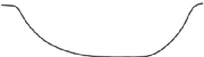
Channel Width and Slope Crossing a Fold
Large Fold
Small Fold
Fig. 8.23
Dependence of
antecedent channel response
on scale and rate of folding.
For sufficiently small folds,
narrowing of the channel width
can accelerate erosion enough to
keep pace with uplift. For larger
folds, narrowing occurs first, but
subsequently the channel also
steepens in order to amplify
erosion. Modified after Amos and
Burbank (2007).
Downstream Distance
Downstream Distance
No Steepening
Channel Steepening
slope
elevation
elevation
slope
Distance
Distance
their outlets; (ii) rivers flowing parallel to the
uplift gradient should show normal concavity
(~0.5), even if the uplift rate is high, because no
differential uplift is occurring along the river's
course; and (iii) antecedent rivers that cross the
fold are likely to have low or even negative
concavity because they tend to steepen as they
cross the zone of high uplift (see Bakeya River;
Fig. 8.21). Studies of river profiles in the foreland
where Lavé and Avouac (2000) completed their
study show precisely this behavior (Fig. 8.24).
The relatively weak rocks in these rapidly
uplifting folds permit rivers to attain apparently
equilibrium profiles, even at Holocene time scales
(Kirby and Whipple, 2001). Such systematic and
tectonically related changes in concavity (and
channel steepness) suggest these fluvial indices,
which can be readily extracted from DEMs, could
be used in a predictive way to identify areas of
strong differential uplift and even to estimate ero-
sion rates (Kirby and Whipple, 2001).
Most of the examples discussed thus far result
from deformation in which the trend of the fault
or fold axis is approximately perpendicular to
the river. What happens when the tilting axis is
more parallel to the river? At least two different
scenarios can be envisioned. In the case of
coseismic deformation, instantaneous tilting
occurs across the affected region, such that
part of the former floodplain may experience
considerable differential subsidence (Fig. 4.26).
The magnitude of displacement can be large
(several meters), and the tilting may cause an
immediate avulsion of rivers into new low points
in the landscape. Alternatively, tilting may occur
incrementally through largely aseismic deforma-
tion or in small coseismic steps, in which case
rivers would respond over longer time scales.
An example of fluvial responses to incremental
tilting is found in northern California, where a
resurgent dome within Long Valley caldera has
inflated and deflated periodically. Between 1979
and 1983 and between 1988 and 1992, the crest
of the dome rose about 40 cm (Fig. 8.25A) and
20 cm, respectively (Castle
et al
., 1984; Langbein
et al
., 1995). The Owens River flows along the
margin of the dome, and, through much of its
course, the river is nearly parallel to the elliptical
contours of the recent domal deformation
(Fig. 8.25A). The recent uplift has not caused
any dramatic shift in the present-day river, but,
as the river flows around the flank of the dome, it
displays two, parallel meander belts (Fig. 8.25B)
separated by 200-300 m (Reid, 1992). Although
both belts show similar meander wavelengths and
amplitudes, the inner belt (closer to the dome)
now contains an underfit stream and is both older
and approximately 60 cm higher in elevation than