Geology Reference
In-Depth Information
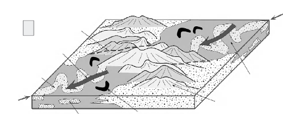
a'
former
floodplain
margin
A
paleoflow
direction
meandering
low-gradient
river
ancient
floodplain
a
rising
mountain
range
former channel
sandstone
oxbow lake
Uplifted, Low-Gradient Fluvial System
B
uplift of
mean su
r
face
minimum
bedrock uplift
a'
a
paleoflow
bedrock uplift
Fig. 7.23
Stratigraphic evidence for surface and bedrock uplift.
A. Stratigraphic evidence for a low-gradient paleoriver system, including meanders, oxbow lakes, and broad floodplains.
Paleoflow direction is across the site of the present mountain range. Correlation of stratal units, plus paleocurrent and
provenance data, imply that a formerly contiguous, low-gradient fluvial system existed prior to mountain growth.
B. Cross-sectional view of the deformed range. Low-gradient river deposits project into the air above the uplifted rock
massif. The amount of surface uplift can be assessed by comparing the mean height of the former depositional surface
with the mean height of the present mountain range. The minimum bedrock uplift can be calculated by projecting
appropriate stratal thicknesses across the summits of the mountains from which they have been eroded.
where rock uplift and dissection have occurred at
rapid rates over the past few million years, Bull
and Cooper (1986) used the presence of rounded
“beach” pebbles on beveled spurs as a basis for
defining remnants of former abrasion platforms
more than 1000 m above present sea level.
depositional systems near the continental margins
have low gradients. The presence in the strati-
graphic record of extensive floodplains, swamps,
meandering rivers, estuaries, or fine-grained and
far-travelled sediments generally indicates a
low-gradient depositional system. Particularly if
“low-gradient” terrestrial deposits can be corre-
lated with nearby marine strata of the same age,
an inference that the terrestrial system was devel-
oped close to sea level is reasonable. If these strata
are now incorporated into a mountain range, the
rock uplift of individual points and the change in
mean surface elevation can be estimated by com-
paring the mean present topography with the
extent of the former low-lying depositional area.
More commonly, such “low-elevation” strata are
preserved not within the mountains, but along
their flanks. If one could demonstrate that strata
on opposite sides of the range correlate with each
Stratigraphic constraints
As soon as the terrestrial realm is entered, the sea-
level reference frame is removed from direct
observation. This absence presents a formidable
challenge when trying to interpret rock or surface
uplift. Common sense and geological observation,
however, tell us that both depositional environ-
ments and the characteristics of river systems tend
to vary in systematic, predictable ways as one
heads upstream from the coast. Except where
mountains are present adjacent to the coast,