Geology Reference
In-Depth Information
2004). In the case of New Zealand,
e
is estimated
to be 0.05 (Hovius
et al.
, 1997). Integrating over
the distribution of landslide sizes, the total vol-
ume eroded by landslides is then modeled as
Landslide Frequency-Magnitude
landslide frequency
binned by size of landslide
10
-2
slope = -
b
βεκ
32
1
−
b
2
(3
L
(7.5)
=
V
−
2 )
β
10
-3
10
-4
where
L
1
is the maximum length of a landslide
in a particular setting and is limited by the
available relief. In the Southern Alps,
L
1
is
estimated at about 1 km, and the erosion rate
that is calculated from the above equation
averages 9 mm/yr over the entire study area
and ranges from 5 to 12 mm/yr within individ-
ual catchments. Although these rates may seem
extraordinarily high, they appear to be consist-
ent both with the rates of long-term denuda-
tion estimated from fission-track ages in the
Southern Alps (Tippett and Kamp, 1993, 1995)
and with intermediate-term (10
4
-10
5
yr) rates
estimated from optically stimulated lumines-
cence (OSL) bedrock ages (Herman
et al.
,
2010). Because the volumetric estimates from
landslides are very sensitive to the value
assigned to
e
(Eqn 7.5), a field-based effort to
quantify
e
is desirable. Interestingly, the rates
of calculated denudation by landsliding, the
rates of rock uplift estimated from fission-track
ages and OSL dating, and the amount of
annual precipitation all co-vary in the Southern
Alps, such that areas of high rainfall, high
landslide denudation, and high rock uplift
spatially coincide. Despite these high rates of
hillslope denudation, the rivers in the Southern
Alps are “underloaded,” such that they export
nearly all of the landslide debris delivered to them,
and they incise their beds at rates essentially
equivalent to the rock uplift rate. Thus, a steady-
state landscape can be envisioned here, where
balanced rates of river incision and landslide
denudation maintain hillslope length and relief
through time (Herman
et al.
, 2007; Willett, 1999).
10
-4
10
-5
10
-3
10
-2
10
-1
area (km
2
)
10
0
10
-3
10
-2
10
-1
Area (km
2
)
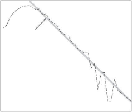
Fig. 7.15
Landslide frequency-magnitude
distributions.
Analysis of the area of
∼
7500 landslides from the
Southern Alps of New Zealand reveals a robust
frequency-magnitude relationship. Inset shows the
area-width relationship for these slides. By relating a
landslide's width to its depth, the landslide frequency-
area distribution can be converted into a denudation
rate. Modified after Hovius
et al.
(1997).
dimensionless scaling exponent equivalent to
the best-fit linear regression through the linear
region of the log-log plot (Fig. 7.15) of the
cumulative distribution. When
b
>
1.5, small
events are predicted to dominate both the total
area covered by landslides and the total landslide
denudation, whereas if
b
<
1.5, large events are
more volumetrically important. In the Southern
Alps,
b
=
1.17, indicating the statistical importance
of events with larger areas (Hovius
et al.
, 1997).
Similar studies from the Transverse Ranges of
southern California yielded
b
values of 1.1
±
0.15
(Lavé and Burbank, 2004).
In order to determine the volume of erosion
attributable to landsliding, the aerial extent of a
landslide measured on a photograph has to be
converted to a rock volume. Although the New
Zealand data show a strong relationship between
slide area and width (inset in Fig. 7.15), their
depth is unknown. Studies elsewhere, however,
suggest a linear relationship between landslide
depth (
d
) and either the width (
L
) of the displaced
mass or the square root of its area (
A
), such that
d
=
e
L
or
d
=
e
A
0.5
(Ohmori, 1992; Lavé and Burbank,
Denudation rates derived from cosmogenic
radionuclide techniques at the basin scale
Imagine the power of a technique whereby
analysis of a handful of sand in a modern river


