Geology Reference
In-Depth Information
Reconstructing Eroded Volumes
minimum material
removed across
valley
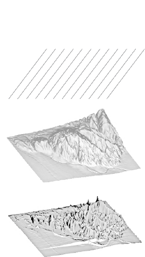
A. Conceptual model
projected surface
to estimate
total erosion
topography
z
y
x
gridded
elevation
data
A
Present topography
1500 m
1000 m
Fig. 7.9
Calculation of volumetric erosion
using a digital elevation model.
A. Strategy for calculating minimum eroded
volume with orthogonal traverses of a digital
elevation model. Subtraction of the present
topography from the filled topography
yields a minimum volume of eroded
material. The actual total mass loss may be
better approximated by connecting the high
points, but requires a more subjective
interpretation. B. Perspective view of the
folded and dissected Wheeler Ridge anticline
in southern California. Note that the fold
plunges to the east where it merges into the
plain and that it is much more dissected in
its western region. C. Perspective view of the
minimum volume of material eroded from
the Wheeler Ridge anticline. The material
removed from the wind and water gaps
is well depicted, but the most erosion
has clearly occurred in the western part
of the fold. Modified after Brozovic
500 m
younger
water
gap
0 m
wind
gap
California
aqueduct
B
600 m
Minimum eroded volume
400 m
older
younger
200 m
0 m
water
gap
wind
gap
6 km
C
4
′
et al.
2
0
(1995).
undissected, state, especially in the early stages
of fold growth. If the geometry of the undis-
sected surface of the fold can be reconstructed,
the modern dissected topography can be sub-
tracted from it in order to define both local and
average rates of erosion. The availability of digi-
tal elevation models can make such calculations
quite straightforward. Minimum eroded volumes
can be objectively calculated simply by filling
each dissected part of the landscape to the height
of the lowest topographic boundary surrounding
it (Brozovic
present topography (Fig. 7.9). Alternatively, a
reconstructed surface that represents the hypoth-
esized topography in the absence of erosion can
be created, and the modern topography (which
has experienced erosion) can be subtracted from
that surface to estimate spatially variable amounts
of erosion (Hilley and Arrowsmith, 2008; Small
and Anderson, 1998).
On a considerably larger scale, former
planation or low-relief surfaces have been iden-
tified in several mountain ranges. These surfaces
may be defined by concordant summits, some
′
et al.
, 1995) and then subtracting the