Geology Reference
In-Depth Information
relatively closely spaced faults that lead to a
spate of earthquakes over a restricted time inter-
val. Recent studies in the western part of the
Eastern California Shear Zone (ECSZ), which lies
just east of the San Andreas Fault (Fig. 6.29),
indicate that clusters of Holocene earthquakes
occurred at about 9, 5.5, and 1 ka (Rockwell
et al.
, 2000). These data suggest that, about
every 4000 years, multiple faults rupture in the
ECSZ over a fairly brief interval (
Spatial and Temporal Clusters
Eastern California Shear Zone
Individual ruptures in ECSZ
Los Angeles Basin
Garlock Fault
10
8
6
4
∼
1000 years).
When viewed in the broader context of south-
ern California (Dolan
et al.
, 2007), these
Holocene events in the ECSZ do not simply rep-
resent temporal clusters, but they appear to be
part of a spatial cluster that alternates through
time, with clustered earthquakes in the broader
Los Angeles basin to the west of the San Andreas
Fault (Fig. 6.29). When viewed together, the
integrated seismic moment release during the
Holocene is much smoother than would be
perceived if the rich data sets from either side
of the San Andreas Fault were viewed in isola-
tion. This holistic overview of fault clustering
suggests that kinematic linkages exist across
this wide (400 km) zone (Dolan
et al.
, 2007).
One possibility is that, when slip is focused
along the Big Bend and central San Andreas
Fault, it both drives compression in the Los
Angeles basin and promotes eastward extru-
sion of the Mojave block, which, in turn, sup-
presses fault slip in the ECSZ (Fig. 6.29C). This
mode of slip may alternate with one in which
more of the southern San Andreas slip is fed
into the ECSZ, thereby decreasing both slip in
the Big Bend and compression across the Los
Angeles basin, while increasing faulting in the
ECSZ (Fig. 6.29D).
This regional overview of southern California
paleoseismicity could only emerge after dozens
of faults had been previously trenched. Despite
these studies, the picture remains incomplete.
Few of the buried thrusts in the Los Angeles
basin are well documented, and many faults
2
0
0
2
4
6
8
10
12
A
Years BP (x10
3
)
0
100
km
200
Eastern Calif.
Shear Zone
LA
Basin
seismic
trade-off?
Pacific
Ocean
B
u
MB
Mojave
block
C
D
MB: Mojave block
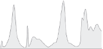
Fig. 6.29
Earthquake clustering in Southern
California.
A. Chronologies of Holocene faulting and estimates of
seismic moment release reveal clustered seismicity based
on data from 10 or more faults on either side of the San
Andreas Fault. B. Map depicting location of studied
faults in the Eastern California Shear Zone (squares) and
the Los Angeles basin (circles). Star indicates location of
Wrightwood (Box 6.3). C. Scenario for suppressed
faulting in the ECSZ when slip is focused through the
Big Bend and central San Andreas Fault (SAF).
D. Scenario for slip being fed into the ECSZ causing
decreased slip rates through the Big Bend and
suppressed Los Angeles basin faulting. Modified after
Dolan
et al.
(2007).