Geology Reference
In-Depth Information
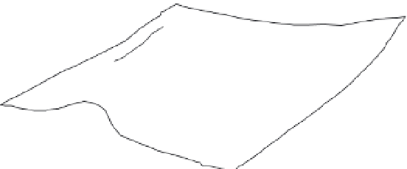
A
temporary ponding
by faulted anticline
poorly drained area
on thrust's footwall
El Asnam anticline
dams El Cheliff River
Fa
ult-Dammed
Lake, Algeria
flow direction
of the Cheliff river
surface breaks
associated with
1980 earthquake
10 km
B
B
Faulted Lacustrine
Stratigraphy
1980 fault scarp
flood horizons
radiocarbon-dated
horizons
2830±70 ybp
2205±75
3810±90
5045±120
2830±70 ybp
4840±120 ybp
4170±70 ybp
5860±80 ybp
4220±80 ybp
8190±90 ybp
1 m
Fig. 6.23
Earthquake-dammed lakes along the Cheliff River, Algeria.
A. Oblique view of the damming of the Cheliff River by the upthrown hanging wall during the 1980 El Asnam
earthquake. The river flows through a water gap, where uplift due to thrusting temporarily dammed the river as it
crossed the upthrown hanging wall. B. Stratigraphy of a trench in the footwall of the El Asnam rupture. Complexly
faulted, but formerly continuous, lacustrine beds are interpreted to result from previous Holocene earthquakes. The
presence of faults cutting the layers and sand blows is used to distinguish those layers that are clearly associated with
major thrust faulting events from those that might be due to natural flooding or landsliding. Note that, although the
master fault is a thrust fault, it occurs at some distance from this site, and all the faults here are small normal faults
developed in the footwall of the thrust. Modified after Meghraoui
et al.
(1988a,b).
surface fissures have been filled with colluvium,
or if abundant vegetation surrounds the surface
trace, then the evidence of a surface rupture
may be removed within a few decades of an
earthquake. Clearly, trenching and radiocarbon
dating of offset layers is one approach to
determine the length of surface rupture. But
trenching is a time-consuming and commonly
expensive undertaking, and several trenches
will probably be needed in order to document
where the rupture terminates.
Tree rings
As discussed earlier in this chapter, the length of
surface ruptures in past earthquakes needs to be
known in order to calculate the seismic moment
that a fault has produced. Hence, reconstruction
of rupture length represents a key objective in
many paleoseismological studies. The geo-
morphic evidence for ground ruptures is ephe-
meral in many settings. If the scarps were
formed in weakly consolidated sediments, if