Geology Reference
In-Depth Information
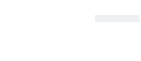
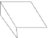
A
B
Biased
Erosion
Offset Terrace
Riser
terrace
riser
present stream
course
preserved
offset
upper terrace
tread
lower terrace
tread
55
Which is
projection of
terrace
trend?
offset corner
susceptible to erosion
offsets:
H = 14.5
vertical
offset
±
2m
V = 1.5
±
0.3m
inset terrace
fault plane with
structure
contours
30
C
Offset Channel
surface rupture
uncertainty in
projection
fault trace
offset channel
Which is
equivalent
contour?
5
corner protected
from erosion
lower terrace
tread
corner vulnerable
to erosion
upper terrace
tread
terrace
riser
10
50
30
Distance west (meters)
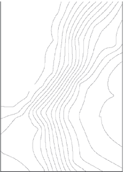
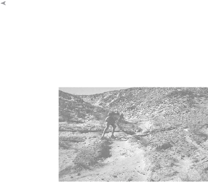
Fig. 6.16
Use of offset terraces and channels to define strike-slip displacements.
A. Gridded and contoured topographic map of late Holocene terrace riser offset by Awatere Fault at Grey River,
Awatere Valley, New Zealand. Map derived from total-station measurements. Dashed lines subparallel to the fault are
two structure contours on the fault plane, which is dipping to the south-southeast (contour interval 1.5 m). Top
structure contour on the fault plane is at the same elevation as the mid-riser contour on the south side of the fault
that is used to project the position of the terrace riser on to the fault plane. Lower structure contour on the fault is
1.5 m lower down (mean throw on both the lower and upper terrace surfaces). Shaded region on south side of fault is
uncertainty in projection of riser contour on to eroded fault surface on upthrown (southeast) side of fault. Shaded
uncertainty belt on north side of fault represents uncertainty in knowledge of which contour on north side of fault
originally corresponded to the south-side riser contour prior to displacement. This uncertainty is the same as that in
throw for the lower terrace surface (
±
0.3 m). Modified after Little
et al.
(1998). B. Sketch of the geometry of the
displaced channel wall and terrace and the optimal position in which to measure offset along the fault. The offset
“corner” to the right of the stream is likely to be modified by erosion as the stream impinges on it. Therefore, it is far
better to measure the displacement based on the protected channel wall on the opposite side of the channel. Modified
after McGill and Sieh (1991). C. Offset channel along the Superstition Hills Fault.
Along strike-slip faults with offset fluvial fea-
tures, erosion along an active channel can con-
tinue to modify offset markers (Cowgill, 2007).
Consider, for example, terrace risers that are
coseismically offset on each bank of a river. The
riser on the downstream side of the fault will be
moved toward the thalweg of the active river,
whereas the other riser will be moved away
from the thalweg (Fig. 6.16C). Any subsequent
erosion of the marker moved toward the chan-
nel will tend to reduce its apparent amount of
offset (Fig. 6.16B), whereas the opposite riser
should be protected from erosion and is more
likely to preserve the initial offset. As with nearly
all efforts to measure fault slip with surface off-
sets, careful reconstruction of the history of the
landscape provides the critical underpinning for
reliable assessments of fault offsets (Box 6.1).
Clearly, vertical displacements can also be
measured using a similar methodology, but one
that relies on projections of subhorizontal
features, such as terrace treads or channel