Geology Reference
In-Depth Information
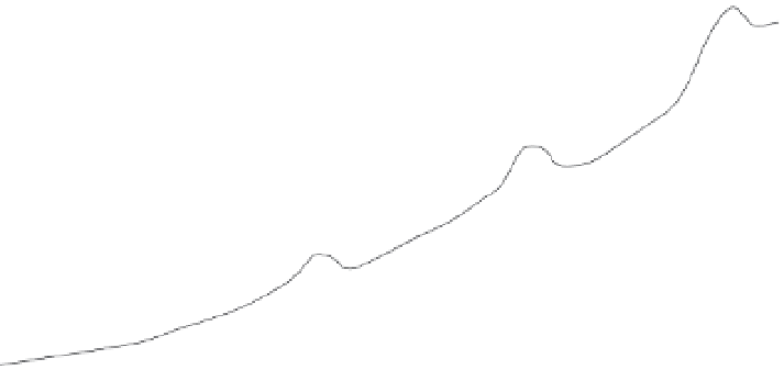
A
Uplifted Beach Ridges:
Old Interpretation
uplift in still older
quake = 8 m
beach ridges at
Turakirae Head,
New Zealand
berm built prior to
previous quake
uplift in previous
quake = 5.5 m
1855 berm
Fig. 6.13
Coseismically raised
beach ridges at Turakirae
Head, New Zealand.
A. In the earlier interpretation of
these ridges, the beach ridge
2.3 m above the modern
high-tide line was interpreted to
represent the vertical coseismic
uplift of the 1855 earthquake.
B. At present, this ridge is
recognized as the active storm
ridge (
+
2.3 m), whereas the
second ridge was raised
∼
6 m in
the 1855 Wairarapa earthquake.
Other, more inland, ridges
resulted from additional
earthquakes since about 8000
years ago when the Quaternary
sea-level rise ended.
Pacific Ocean
uplift in 1855
quake = 2.3 m
present high tide line
B
berm built prior to
previous quake
Uplifted Beach Ridges:
New Interpretation
uplift in previous
quake = 8 m
1855 berm
uplift in 1855
quake = 5.5 m
modern storm
berm
Pacific Ocean
2.3 m: height of
modern storm berm
Coke can!
present high tide line
the beach ridge at 2.3 m above the modern
shoreline was interpreted as representing uplift
due to the 1855 earthquake (Fig. 6.13A). The
underlying idea was that this ridge formed at
the pre-1855 high-tide line, and presumably a
new ridge was forming at the present-day high-
tide line. The discovery of late 20th-century
human litter in the lowest beach ridge indicates,
however, that it formed during major storms
long after the 1855 earthquake (Fig. 6.13B).
Re-examination of the pre-1855 historical record
confirms that there was indeed a beach ridge
present 2-3 m above high-tide line prior to the
earthquake and that this ridge was displaced
nearly 6 m during the earthquake. The amount
of coseismic uplift (2.3 m) calculated under the
earlier interpretation is only half of the actual
uplift (
∼
6 m), as represented by the difference
in altitude of the second ridge and the lowest
(Fig. 6.13). Clearly, knowledge of the positions
and geometries of potential geomorphological
markers in modern conditions underpins
reliable reconstructions of past earthquakes.
A fortuitous combination of repetitive creation
of shoreline features, preservation of key aspects
of their geometry through time, and unearthing
of datable material commonly marks the quest to
discover useful paleoseismic records in typically
high-energy shoreline environments. For beach
ridges, abrupt uplift by seismic events is a key to
their preservation. If they slowly emerged, a
broad shingled bench of composite age would
be created, rather than a discretely crested berm.
A surprisingly rich paleoseismic record has been
recently described (Bookhagen
et al.
, 2006) from
a suite of 20 uplifted beach ridges from Santa
María Island along the coast of Chile (Fig. 6.14).
At the time of their formation, these ridges were
only 0.5-1 m high, and, today, the entire succes-
sion lies less than about 10 m above sea level.
Their preservation depends on their orientation:
they face eastward, away from the open Pacific
Ocean, and they have been gradually uplifted
above an east-vergent thrust fault. Dates from
optically stimulated luminescence on the buried
sands within the berms define a late Holocene