Geology Reference
In-Depth Information
A
B
Faulting Chronology
Trench Cross Section
east
west
steepest part of 7-m-high
fault scarp
soillcolluvial
sequences
8
980±70
14
C BP
400±100 yr (TL)
140±120
14
C yr BP
2620±70
14
C yr BP
2700±300 yr (TL)
A
140
±
120
14
C yr BP
Ak
7
A
Ak
500
±
200 yr ago
400
±
100 yr
980
±
70
14
C yr BP
Event
1
1
6
A
A
2
Bk
5
Ak
Bk
A
3
4
Bk
2650
±
250 yr ago
Event
2
C
3
2700
±
300 yr
2620
±
70
14
C yr BP
fault x
fault y
4
A
Bk
2
4740±90
14
Cyr BP
C
1
Event
3
5300
±
300 yr ago
0123456789
Distance along trench wall (m)
A
4740
±
90
14
C yr BP
Colluvial/lake deposits
Fault-scarp colluvium
sand and gravel
slope deposits
fault zone
A soil horizon
Ak, Bk soil horizon
C soil horizon
distal scree (gravel
Event
4
5500 - 8,000 yr ago
6600
±
700
14
C yr BP
Eolian silt
debris flow
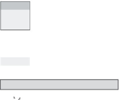
Fig. 6.6
Record of normal faulting along the Wasatch Fault, Utah.
Data from a trenched fault that bounds the Wasatch Range near American Fork Canyon, Utah. A. Evidence for three
faulting events is revealed in this trench. The excavation is
>
9 m deep, and yet, because markers typically show 1-3 m
of offset per earthquake, only three rupture events are recorded here. A repetitive soil zonation (A
−
Ak
±
Bk)
delineates the top of each of three colluvial wedges (labeled 1 through 3). The magnitude of offset for each wedge
can be estimated by restoring the top surface of the wedge back to the ground surface such that the “A” soil horizon
is continuous on to the upthrown block. Radiocarbon and thermoluminescence dates are used to constrain the timing
of faulting events. Cross-cutting relationships with faults and soils define rupture events. Fault “x” cuts soil sequence 3
and is overlain by sequence 2. Fault “y” cuts soil sequences 2 and 3, but is overlain by sequence 1. Note that, with the
exception of the lowest and topmost stratigraphic units on the downthrown side, none of the downthrown strata are
represented on the upthrown block. B. Interpretation of the rupture history based on the trench stratigraphy.
Evidence for the oldest faulting event is based on a nearby trench. Note that, on this trenched segment of the Wasatch
Fault, ruptures appear to be evenly spaced in time, but the magnitude of rupture varies, with the latest offset (
∼
1 m)
being about half as large as the offsets during the previous two events. Modified after Machette
et al.
(1992a).
along the fault. If it can be shown that the same
stratigraphic level in several places overlies fault
traces, the likelihood increases that this rupture
represents a fault that did propagate to the
surface.
The stratigraphy of soils can provide useful
controls on the interpretation of trench strati-
graphy. For example, colluvial wedges (Figs 6.4C
and 6.6) are often associated with dip-slip faults.
Each colluvial wedge is commonly interpreted
to result from a single rupture of the bounding
fault (Machette
et al.
, 1992b; Schwartz and
Coppersmith, 1984). Steepening of slopes,
localized uplift, or overthrusting of the land
surface along a rupture plane destabilizes
weakly consolidated surface strata. Quaternary
sediments that have been uplifted to a higher
topographic position along these steepened
slopes quickly erode and produce colluvial
wedges that accumulate along the toe of the